IMAGES TAKEN NEAR TO
HINCKLEY, LE10 1YA
Introduction
This page details the photographs taken nearby to LE10 1YA by members of the Geograph project.
The Geograph project started in 2005 with the aim of publishing, organising and preserving representative images for every square kilometre of Great Britain, Ireland and the Isle of Man.

There are currently over 7.5m images from over14,400 individuals and you can help contribute to the project by visiting https://www.geograph.org.uk
Image Map (Loading...)


Getting Data...Please wait
Leaflet Map data © OpenStreetMap
Images are licensed for reuse under creativecommons.org/licenses/by-sa/2.0
Notes
- Clicking on the map will re-center to the selected point.
- The higher the marker number, the further away the image location is from the centre of the postcode.
Image Listing (18 Images Found)
Images are licensed for reuse under creativecommons.org/licenses/by-sa/2.0
Image
Details
Distance
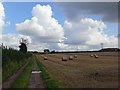
2
Farmland north of Hinckley
This field is located alongside the A47 Normandy Way and Stoke Road.
Image: © Mat Fascione
Taken: 13 Sep 2008
0.09 miles
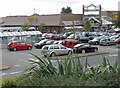
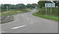
3
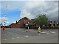
Towards Stoke Road/Normandy Way roundabout
The view is from Stoke Road. Morrisons is on the other side of Normandy Way which is the A47 Hinckley Bypass.
Image: © Andrew Tatlow
Taken: 3 May 2017
0.11 miles
5
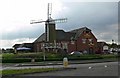
The Milestone at Hinckley
A restaurant located on Sword Drive and the A47 Normandy Way, on the northern edge of Hinckley.
Image: © Mat Fascione
Taken: 13 Sep 2008
0.11 miles
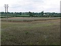
8
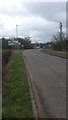
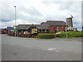
Stoke Road
Stoke Road is shown here on its approach to the busy A47 on the northern edge of Hinckley.
Image: © Peter Mackenzie
Taken: 21 Feb 2017
0.13 miles
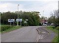
9
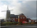
Stoke Road heading towards Stoke Golding
Image: © Mat Fascione
Taken: 13 Sep 2008
0.17 miles