IMAGES TAKEN NEAR TO
Albert Road, HINCKLEY, LE10 1PL
Introduction
This page details the photographs taken nearby to Albert Road, LE10 1PL by members of the Geograph project.
The Geograph project started in 2005 with the aim of publishing, organising and preserving representative images for every square kilometre of Great Britain, Ireland and the Isle of Man.

There are currently over 7.5m images from over14,400 individuals and you can help contribute to the project by visiting https://www.geograph.org.uk
Image Map (Loading...)


Getting Data...Please wait
Leaflet Map data © OpenStreetMap
Images are licensed for reuse under creativecommons.org/licenses/by-sa/2.0
Notes
- Clicking on the map will re-center to the selected point.
- The higher the marker number, the further away the image location is from the centre of the postcode.
Image Listing (85 Images Found)
Images are licensed for reuse under creativecommons.org/licenses/by-sa/2.0
Image
Details
Distance
2
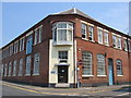
Graphic House
The factory on the Corner of Druid Street and Spencer Street. It used to be the Sunbro Hosiery Works during the 19th and early 20th Century, and now it continues to be a business base, being the home of several offices for small businesses. Restoration began in 2005 and is still ongoing...
Image: © Kirsty Huddlestone
Taken: 4 Jul 2006
0.03 miles
3
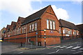
Holliers Walk Primary School
There is an Ordnance Survey flush bracket benchmark (http://www.bench-marks.org.uk/bm13156 ) on the Albert Road (left hand) face of the school near its far end (by the yellow car).
Image: © Roger Templeman
Taken: 1 Oct 2015
0.05 miles
4
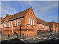
Hinckley-Holliers Walk
Primary School at the corner of Albert Road.
Image: © Ian Rob
Taken: 9 Nov 2012
0.06 miles
5
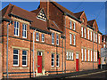
Hinckley - school on Holliers Walk
For an alternative view, please see Image
Image: © Dave Bevis
Taken: 28 Dec 2013
0.07 miles
6
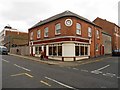
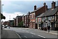
Hinckley-Upper Bond Street
Funeral Director on the corner of Well Lane. The clock was working.
Image: © Ian Rob
Taken: 9 Nov 2012
0.08 miles
7
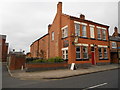
Hinckley-The Queen's Head
Public House on Upper Bond Street.
Image: © Ian Rob
Taken: 9 Nov 2012
0.09 miles
8
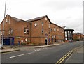
Hinckley Police Station And Magistrates Court
In Upper Bond Street.
Image: © Ian Rob
Taken: 9 Nov 2012
0.09 miles
9
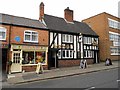
Hinckley: Upper Bond Street
The public house on the right is the Black Horse.
Image: © Mat Fascione
Taken: 13 Sep 2008
0.09 miles
10
Hinckley-The Black Horse
The second of two public houses, close together in Upper Bond Street
Image: © Ian Rob
Taken: 9 Nov 2012
0.10 miles