IMAGES TAKEN NEAR TO
High Street, PRESTEIGNE, LD8 2BB
Introduction
This page details the photographs taken nearby to High Street, LD8 2BB by members of the Geograph project.
The Geograph project started in 2005 with the aim of publishing, organising and preserving representative images for every square kilometre of Great Britain, Ireland and the Isle of Man.

There are currently over 7.5m images from over14,400 individuals and you can help contribute to the project by visiting https://www.geograph.org.uk
Image Map
Images are licensed for reuse under creativecommons.org/licenses/by-sa/2.0
Notes
- Clicking on the map will re-center to the selected point.
- The higher the marker number, the further away the image location is from the centre of the postcode.
Image Listing (542 Images Found)
Images are licensed for reuse under creativecommons.org/licenses/by-sa/2.0
Image
Details
Distance
2

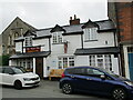
Royal Oak, Presteigne
Pub at the NE end of High Street. I don't know if the line of parked vehicles indicates the Royal Oak's popularity or merely a convenient place to park...
Image: © Jaggery
Taken: 19 Mar 2014
0.01 miles
3
![Presteigne houses [46]](https://s0.geograph.org.uk/geophotos/06/96/25/6962556_f0ab1d8e_120x120.jpg)
Presteigne houses [46]
Numbers 1, 2 and 3 Warden View, High Street is a later 19th century block of houses. Built of red brick with blue brick and ashlar dressings to the front and side with a rubble stone rear wall, all under a slate roof. Listed, grade II, with details at: https://cadwpublic-api.azurewebsites.net/reports/listedbuilding/FullReport?lang=&id=8887
Presteigne is a market town, set on the south bank of the River Lugg, some 19 miles northwest of Hereford and 16 miles east of Llandrindod Wells. The Welsh/English border wraps around three sides of the town, which probably began as a small settlement around a Minster church. Formerly the county town of the historic county of Radnorshire, it remains quiet, picturesque and unspoilt.
Image: © Michael Dibb
Taken: 2 Jun 2021
0.01 miles
4
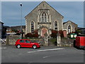
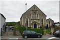
Presteigne Methodist chapel and hall
Viewed across the B4356 from the corner of Warden Road. Part of the Southern Area of the Shropshire and Marches Methodist Circuit, the chapel was built in the 1860s. The hall on the right was added in 1888 as a school room.
Image: © Jaggery
Taken: 19 Mar 2014
0.01 miles
5
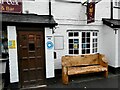
Bench outside the Royal Oak in High Street
A cut above the usual bench, the inscription reads
"In loving memory of
Nigel Powell ("Nige")
Many a pint or two drank here
putting the world to rights!
A true legend"
Image: © Oliver Dixon
Taken: 5 Aug 2021
0.01 miles
6
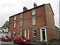
Houses, High Street, Presteigne
Nineteenth century red brick is uncommon in Presteigne https://cadwpublic-api.azurewebsites.net/reports/listedbuilding/FullReport?lang=en&id=8887
Image: © Jonathan Thacker
Taken: 22 Aug 2022
0.01 miles
7
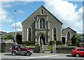
Methodist Chapel and hall, Presteigne
The chapel is dated 1867, the hall 1888. Although not indicated on the inscription over the entrance, this was built by the Primitive Methodists. Listed Grade II for group value.
Image: © Alan Murray-Rust
Taken: 26 Apr 2016
0.01 miles
8
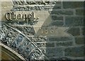
Datestone on the Methodist Chapel, Presteigne
See http://www.geograph.org.uk/photo/4929116 for location.
Image: © Alan Murray-Rust
Taken: 26 Apr 2016
0.01 miles
9
![Presteigne buildings [30]](https://s1.geograph.org.uk/geophotos/06/96/25/6962561_14e15432_120x120.jpg)
Presteigne buildings [30]
The church was built as a Methodist chapel in 1867. Constructed, in a Gothic style, of rubble stone with ashlar dressings under a slate roof. The church hall, to the right, in similar style, is dated 1888. The forecourt has rubble stone walls with fine pinnacled gate piers with iron railings and gate. Listed, grade II, with details at: https://cadwpublic-api.azurewebsites.net/reports/listedbuilding/FullReport?lang=&id=8921
Presteigne is a market town, set on the south bank of the River Lugg, some 19 miles northwest of Hereford and 16 miles east of Llandrindod Wells. The Welsh/English border wraps around three sides of the town, which probably began as a small settlement around a Minster church. Formerly the county town of the historic county of Radnorshire, it remains quiet, picturesque and unspoilt.
Image: © Michael Dibb
Taken: 2 Jun 2021
0.01 miles