IMAGES TAKEN NEAR TO
Church Road, KNIGHTON, LD7 1EB
Introduction
This page details the photographs taken nearby to Church Road, LD7 1EB by members of the Geograph project.
The Geograph project started in 2005 with the aim of publishing, organising and preserving representative images for every square kilometre of Great Britain, Ireland and the Isle of Man.

There are currently over 7.5m images from over14,400 individuals and you can help contribute to the project by visiting https://www.geograph.org.uk
Image Map
Images are licensed for reuse under creativecommons.org/licenses/by-sa/2.0
Notes
- Clicking on the map will re-center to the selected point.
- The higher the marker number, the further away the image location is from the centre of the postcode.
Image Listing (420 Images Found)
Images are licensed for reuse under creativecommons.org/licenses/by-sa/2.0
Image
Details
Distance
1
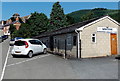
Knighton Bowling Club
The club's bowling green is behind the Church Road clubhouse.
Image: © Jaggery
Taken: 26 Aug 2013
0.00 miles
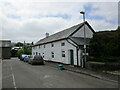
4
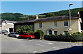
Ystrad House, Knighton
Viewed from Station Road. Ystrad House, at the southern end of Church Road,
dates from the early 19th century. Grade II listed in 1985.
Image: © Jaggery
Taken: 26 Aug 2013
0.03 miles
5
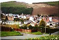
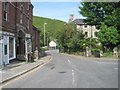
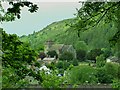
Descent into Knighton
For northbound walkers on Offa's Dyke Path, this sight is a welcome relief as it probably means end of the day. But they can also see that Panpunton Hill behind the town will be a stiff climb first thing in the morning.
Image: © Graham Horn
Taken: 20 Apr 2000
0.04 miles
6
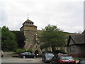
Church of St Edward, Knighton
Possibly of Norman origin, but rebuilt several times, and now largely Victorian
Image: © Tim Heaton
Taken: 18 May 2008
0.04 miles
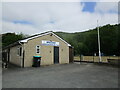
7
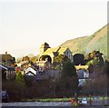
Knighton parish church
The evening sunlight heightens the superb location of this prominent building behind the town centre.
Image: © Flying Stag
Taken: Unknown
0.04 miles
8
![Knighton houses [2]](https://s3.geograph.org.uk/geophotos/06/93/98/6939847_6fa56ac6_120x120.jpg)
Knighton houses [2]
Ystrad House is on the corner of Church Road and Station Road. Built in the early 19th century incorporating an earlier structure. Constructed of roughcast rendered brick under a slate roof. Listed, grade II, with details at: https://cadwpublic-api.azurewebsites.net/reports/listedbuilding/FullReport?lang=&id=8978
Knighton is a somewhat remote market town gaining its charter in 1203. It is sited on the River Teme some 60 miles north of Cardiff. It lies on the Welsh/English border, with a small part in Shropshire, including its railway station. Originally an Anglo-Saxon settlement, Knighton is located on Offa's Dyke, the ancient earthwork that divided the two countries. It later became a Norman defensive border town.
Image: © Michael Dibb
Taken: 31 May 2021
0.05 miles
9
St. Edward's Church, Knighton
St. Edward's Church, Knighton, Powys viewed from the Bryn Y Castell ground of Knighton Town Football Club.
Image: © Peter Evans
Taken: 15 Jun 2013
0.05 miles