IMAGES TAKEN NEAR TO
Lower Chapel, BRECON, LD3 9RD
Introduction
This page details the photographs taken nearby to LD3 9RD by members of the Geograph project.
The Geograph project started in 2005 with the aim of publishing, organising and preserving representative images for every square kilometre of Great Britain, Ireland and the Isle of Man.

There are currently over 7.5m images from over14,400 individuals and you can help contribute to the project by visiting https://www.geograph.org.uk
Image Map
Images are licensed for reuse under creativecommons.org/licenses/by-sa/2.0
Notes
- Clicking on the map will re-center to the selected point.
- The higher the marker number, the further away the image location is from the centre of the postcode.
Image Listing (5 Images Found)
Images are licensed for reuse under creativecommons.org/licenses/by-sa/2.0
Image
Details
Distance
1
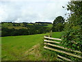
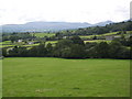
Pasture land south-west of Coedmawr.
The wood in the distance is at Cefn Sarnau on Battle Hill. In between is Nant y Groes dingle.
Image: © Jonathan Billinger
Taken: 15 Aug 2008
0.12 miles
3
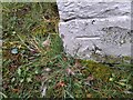
Ordnance Survey Cut Mark
This OS cut mark can be found on the NE angle of the chapel. It marks a point 221.363m above mean sea level.
Image: © Adrian Dust
Taken: 18 Feb 2023
0.24 miles
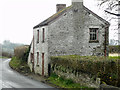
5
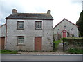
Bethel chapel and manse
An abandoned manse with its chapel behind.
Can't a chapel house someone here who would mow the graveyard, monitor the premises and return some life to this manse?
Or is the manse unfit for habitation in the 21st century?
Image: © Jeremy Bolwell
Taken: 6 May 2012
0.25 miles