IMAGES TAKEN NEAR TO
Sennybridge, BRECON, LD3 8SR
Introduction
This page details the photographs taken nearby to LD3 8SR by members of the Geograph project.
The Geograph project started in 2005 with the aim of publishing, organising and preserving representative images for every square kilometre of Great Britain, Ireland and the Isle of Man.

There are currently over 7.5m images from over14,400 individuals and you can help contribute to the project by visiting https://www.geograph.org.uk
Image Map
Images are licensed for reuse under creativecommons.org/licenses/by-sa/2.0
Notes
- Clicking on the map will re-center to the selected point.
- The higher the marker number, the further away the image location is from the centre of the postcode.
Image Listing (7 Images Found)
Images are licensed for reuse under creativecommons.org/licenses/by-sa/2.0
Image
Details
Distance
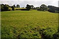
1
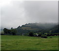
Fields
Tylebychan is visible just below centre left
Image: © Bonelli
Taken: Unknown
0.02 miles
2
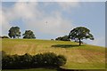
Red kite above a hill
The unmistakable sight of a red kite flying above this field near Cwm Panteinon.
Image: © Philip Halling
Taken: 19 Sep 2015
0.15 miles
3
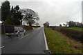
The A4125 near Defynnog
Taken in the rain. The hill is steeper than it appears here, especially when you're on foot!
Image: © John Winder
Taken: 11 Nov 2014
0.18 miles
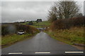
4
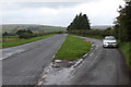
Lay-by on A4215 from Defynnog
The lay-by may have been the route of the old A4215.
Image: © M J Roscoe
Taken: 18 Sep 2018
0.20 miles
5
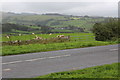
Sheep pasture next to A4215
Sheep grazing on an overcast autumn day in the Brecon Beacons National Park.
Image: © M J Roscoe
Taken: 18 Sep 2018
0.21 miles
7
Farm track to Llwynstyffillin
A farm track to a place which appears to be missing a couple of vowels! Taken on our grim trudge through the rain on our way back from a closed pub.
Image: © John Winder
Taken: 11 Nov 2014
0.23 miles