1
Panorama from A40 near Bwlch, 1993
View SE down the Usk Valley, with slopes of Pen-Cerig-Calch on left, Myarth centre-right, Sugar Loaf beyond.
Image: © Ben Brooksbank
Taken: 1 Jun 1993
0.01 miles
2
View from Bwlch
In the middle distance is the wooded dome of Myarth.
See
Image for a similar view in the autumn of 2008.
Scrubby steep land in the foreground is in square.
Image: © Jonathan Billinger
Taken: 14 Jan 2015
0.05 miles
3
Old Road
Old Road heading down to the A40
Image: © Shaun Ferguson
Taken: 22 Jun 2013
0.06 miles
4
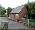
Smaller of two buildings in the BT telephone exchange compound, Bwlch
Located at the southern end of Old Road, near the A40 junction. There is a larger building http://www.geograph.org.uk/photo/2998972 on the northern side of the compound.
Image: © Jaggery
Taken: 17 Jun 2012
0.06 miles
5
Larger of two buildings in the BT telephone exchange compound, Bwlch
At the southern end of Old Road, near the A40 junction, to the north of this smaller building. http://www.geograph.org.uk/photo/2998955
Image: © Jaggery
Taken: 17 Jun 2012
0.06 miles
6
No entry to Old Road, Bwlch
Formerly part of the main road through Bwlch, narrow Old Road is suitable only for one lane of modern traffic, towards the camera. The main road (the A40) now follows a much wider route to the east of here.
Image: © Jaggery
Taken: 17 Jun 2012
0.06 miles
7
A40 passes the southern end of Old Road, Bwlch
The course of the main road through the Powys village of Bwlch formerly turned left here, up what is now known as Old Road. The narrow road http://www.geograph.org.uk/photo/2998918 was unsuitable for the increasing volume of traffic, so a new, wider road (ahead) was built. The No Entry signs show that Old Road today is a one-way road.
Image: © Jaggery
Taken: 17 Jun 2012
0.06 miles
8
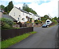
Houses near the southern end of Old Road, Bwlch
A view looking north up Old Road, formerly the route taken by the A40 through part of the village of Bwlch, Powys. The present-day route of the A40 is to the east of Old Road.
Image: © Jaggery
Taken: 17 Jun 2012
0.08 miles
9
1930's style cottage on Darran Road, Bwlch, Powys
This style of cottage dates from the 1930's I believe. They picked their spot wisely. Nice to see it surviving so far, rather than being re-developed.
Image: © Jeremy Bolwell
Taken: 27 Mar 2012
0.09 miles
10
A40 south of Bwlch, Powys
Ahead for Crickhowell and Abergavenny.
Image: © Jaggery
Taken: 21 Apr 2019
0.09 miles


