IMAGES TAKEN NEAR TO
The Struet, BRECON, LD3 7LN
Introduction
This page details the photographs taken nearby to The Struet, LD3 7LN by members of the Geograph project.
The Geograph project started in 2005 with the aim of publishing, organising and preserving representative images for every square kilometre of Great Britain, Ireland and the Isle of Man.

There are currently over 7.5m images from over14,400 individuals and you can help contribute to the project by visiting https://www.geograph.org.uk
Image Map
Images are licensed for reuse under creativecommons.org/licenses/by-sa/2.0
Notes
- Clicking on the map will re-center to the selected point.
- The higher the marker number, the further away the image location is from the centre of the postcode.
Image Listing (400 Images Found)
Images are licensed for reuse under creativecommons.org/licenses/by-sa/2.0
Image
Details
Distance
1
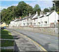
The Struet houses, Brecon
Though shown on Ordnance Survey maps as simply 'Struet' most other references are to 'The Struet'. The Struet's course is SW-NE along the east bank of the River Honddu, which is a few metres to the west here (beyond the left edge of the view). The houses, on the east side of The Struet, are opposite houses in Honddu Court.
Image: © Jaggery
Taken: 7 Aug 2011
0.04 miles
2
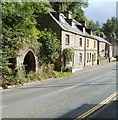
Houses at the northern end of The Struet, Brecon
Next to the houses is a partly-overgrown arched doorway to nowhere.
Image: © Jaggery
Taken: 7 Aug 2011
0.04 miles
3
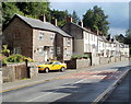
Houses near the northern end of The Struet, Brecon
The Struet is on the east bank of the River Honddu, a tributary of the Usk.
Image: © Jaggery
Taken: 7 Aug 2011
0.04 miles
4
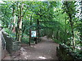
Riverside path through Priory Groves, Brecon
The path is along the west bank of the River Honddu.
Image: © Jaggery
Taken: 21 Jul 2013
0.06 miles
5
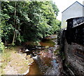
River Honddu flows towards a footbridge, Brecon
Viewed from this http://www.geograph.org.uk/photo/3575821 footbridge.
Image: © Jaggery
Taken: 21 Jul 2013
0.06 miles
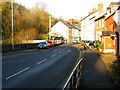
6
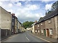
The Struet
One of the main roads leading into Brecon. It runs alongside the river Honddu to the north of the city and contains several Grade II listed buildings.
Image: © Alan Hughes
Taken: 30 Aug 2019
0.07 miles
7
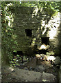
Holy waters?
An ancient spring emerges from the hillside above the Honddu as it enters Brecon. The Cathedral is but a short walk away, handily.
Image: © Neil Owen
Taken: 25 Jul 2012
0.08 miles
8
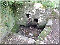
The Priory Well
Somewhat drier now perhaps than hitherto?
Image: © Alan Bowring
Taken: 7 Aug 2015
0.08 miles
10
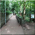
Path through Priory Groves, Brecon
The path climbs away from the River Honddu towards Brecon Cathedral
Image: © Jaggery
Taken: 21 Jul 2013
0.08 miles