IMAGES TAKEN NEAR TO
Llanddew, BRECON, LD3 0TS
Introduction
This page details the photographs taken nearby to LD3 0TS by members of the Geograph project.
The Geograph project started in 2005 with the aim of publishing, organising and preserving representative images for every square kilometre of Great Britain, Ireland and the Isle of Man.

There are currently over 7.5m images from over14,400 individuals and you can help contribute to the project by visiting https://www.geograph.org.uk
Image Map
Images are licensed for reuse under creativecommons.org/licenses/by-sa/2.0
Notes
- Clicking on the map will re-center to the selected point.
- The higher the marker number, the further away the image location is from the centre of the postcode.
Image Listing (6 Images Found)
Images are licensed for reuse under creativecommons.org/licenses/by-sa/2.0
Image
Details
Distance
1
Drive to Little Llether
Track runs parallel to the A470 unseen to the left.
Image: © Jonathan Billinger
Taken: 29 Jan 2015
0.09 miles
2
Roadside Embankment
A470 embankment. Gateway on left into field shows tarmac from the old main road course.
Image: © Bonelli
Taken: Unknown
0.12 miles
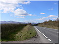
3
Traffic on the A470
Traffic not-so-carefully descending the pitch towards Brecon and the Usk valley.
Image: © Jonathan Billinger
Taken: 14 Jan 2015
0.13 miles
4
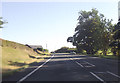
A470 at Blaen-Brynich
Junction ahead for Lower Penwaen
Image: © John Firth
Taken: 7 Sep 2012
0.13 miles
5
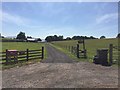
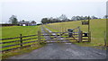
Little Llether Farm
Entrance to Little Llether farm.
Image: © Alan Hughes
Taken: 6 Jun 2018
0.17 miles
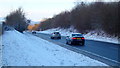
6
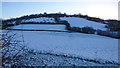
Northern slopes of Yr Allt
Photo taken from the A470 on a cold January morning.
Image: © Jonathan Billinger
Taken: 14 Jan 2015
0.25 miles