1
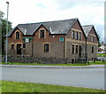
Trefecca Road houses viewed from the SW, Talgarth
Viewed across the B4560. http://www.geograph.org.uk/photo/3226647 to another view.
Image: © Jaggery
Taken: 14 Aug 2011
0.02 miles
2
SW boundary of Talgarth
The western Talgarth bypass (A479) reaches the green Talgarth boundary signs, one on each side of the road behind the 30mph speed limit signs.
Image: © Jaggery
Taken: 24 Jun 2012
0.04 miles
3
Track to a field alongside the A479, Talgarth
The track, parallel with the A479, ascends towards a field. Behind the camera is the roundabout at the western end of High Street, at the junction with Trefecca Road and the A479.
Image: © Jaggery
Taken: 24 Jun 2012
0.04 miles
4
Gwernyfed RFC clubhouse, Talgarth
Located on Trefecca Road. The rugby club's playing ground is nearby. http://www.geograph.org.uk/photo/3202380
Image: © Jaggery
Taken: 14 Aug 2011
0.05 miles
5
Trefecca Road houses viewed from the NE, Talgarth
Viewed from the edge of the B4560. The houses are in the SW of Talgarth.
http://www.geograph.org.uk/photo/3226830 to another view.
Image: © Jaggery
Taken: 14 Aug 2011
0.06 miles
6
A479 Roundabout, Talgarth
Talgarth is a small market town and community in southern Powys, with a population of 1,645 (2001 census data).
Image: © David Dixon
Taken: 14 Apr 2016
0.07 miles
7
End of the 30mph zone in Talgarth
A view SW along the B4560. The 30mph speed limit sign is on the back of the National Speed Limit sign (a diagonal black line on a white background).
Image: © Jaggery
Taken: 14 Aug 2011
0.07 miles
8
A479 approaches Talgarth from the south
The large green sign shows which road to take for Hereford or Builth Wells
at the roundabout 250 metres ahead.
Image: © Jaggery
Taken: 24 Jun 2012
0.07 miles
9
Near the end of the A479 descent into Talgarth
The A479 descends towards the roundabout at the western edge of Talgarth.
Beyond the roundabout, the A479 continues towards Bronllys.
Image: © Jaggery
Taken: 24 Jun 2012
0.08 miles
10
New House, Talgarth
With an old Esso petrol pump at the roadside.
Image: © Andrew Abbott
Taken: 14 Mar 2020
0.08 miles


