IMAGES TAKEN NEAR TO
Howey, LLANDRINDOD WELLS, LD1 5PL

Introduction

This page details the photographs taken nearby to LD1 5PL by members of the Geograph project.

The Geograph project started in 2005 with the aim of publishing, organising and preserving representative images for every square kilometre of Great Britain, Ireland and the Isle of Man.

There are currently over 7.5m images from over14,400 individuals and you can help contribute to the project by visiting https://www.geograph.org.uk

Image Map


Images are licensed for reuse under creativecommons.org/licenses/by-sa/2.0
Notes
  • Clicking on the map will re-center to the selected point.
  • The higher the marker number, the further away the image location is from the centre of the postcode.

Image Listing (22 Images Found)

Images are licensed for reuse under creativecommons.org/licenses/by-sa/2.0
  • ...
Image
Details
Distance
1
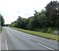
Northern boundary of Howey
The A483 from Llandrindod Wells reaches the village of Howey (Hawy in Welsh).
Image: © Jaggery Taken: 30 Jun 2013
0.03 miles
2
Old Milestone by the A483, Ashfield, Disserth and Trecoed Parish
By the A483, in parish of Disserth and Trecoed (Powys District), Ashfield, in front of garden centre in hedgerow. Inscription reads:- : TO ye / WELLS / TO / BUILTH / 6M : Surveyed Milestone Society National ID: RAD_WLBU01
Image: © Milestone Society Taken: Unknown
0.04 miles
3
Greenacre Garden Centre, Howey
Viewed across the A483.
Image: © Jaggery Taken: 30 Jun 2013
0.04 miles
4
Ordnance Survey Cut Mark
This OS cut mark can be found on the SW buttress of the railway bridge. It marks a point 205.815m above mean sea level.
Image: © Adrian Dust Taken: 24 May 2021
0.05 miles
5
Railway bridge over lane to Ashfield, Howey
Viewed from the edge of the A483. The bridge carries the Heart of Wales railway.
Image: © Jaggery Taken: 30 Jun 2013
0.05 miles
6
Cattle grid and lodge on the lane to Ashfield, Howey
On the west side of this http://www.geograph.org.uk/photo/3536051 bridge.
Image: © Jaggery Taken: 30 Jun 2013
0.06 miles
7
Wellington Road (A483)
Image: © David Dixon Taken: 14 Apr 2016
0.06 miles
8
Fields on the east side of the A483, Howey
A view SE from the A483 between the northern boundary of Howey and the southern boundary of Llandrindod Wells.
Image: © Jaggery Taken: 30 Jun 2013
0.10 miles
9
Disused railway building
Ivy completely envelopes one side of this ruined building alongside the railway track approaching Llandrindod Wells.
Image: © Alan Hughes Taken: 1 Mar 2020
0.11 miles
10
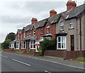
A483 houses, Howey
The A483 is the main road through the village.
Image: © Jaggery Taken: 30 Jun 2013
0.11 miles
  • ...