IMAGES TAKEN NEAR TO
Dolydd Pentrosfa, LLANDRINDOD WELLS, LD1 5NZ

Introduction

This page details the photographs taken nearby to Dolydd Pentrosfa, LD1 5NZ by members of the Geograph project.

The Geograph project started in 2005 with the aim of publishing, organising and preserving representative images for every square kilometre of Great Britain, Ireland and the Isle of Man.

There are currently over 7.5m images from over14,400 individuals and you can help contribute to the project by visiting https://www.geograph.org.uk

Image Map


Images are licensed for reuse under creativecommons.org/licenses/by-sa/2.0
Notes
  • Clicking on the map will re-center to the selected point.
  • The higher the marker number, the further away the image location is from the centre of the postcode.

Image Listing (19 Images Found)

Images are licensed for reuse under creativecommons.org/licenses/by-sa/2.0
Image
Details
Distance
1
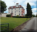
The Highland Moors Guesthouse, Llandrindod Wells
The name sign facing the A483 Wellington Road shows "The last Victorian Hydro Spa Hotel in Wales". The large guesthouse has 13 guest rooms.
Image: © Jaggery Taken: 30 Jun 2013
0.08 miles
2
Llandrindod Wells, Wellington Road
Image: © David Dixon Taken: 14 Apr 2016
0.11 miles
3
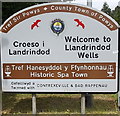
Southern boundary sign, Llandrindod Wells
The boundary sign is here. http://www.geograph.org.uk/photo/3538019 The sign shows that Llandrindod Wells is the County Town of Powys. Depicted are two red kites, birds rarely seen elsewhere in Britain, but thriving here. The historic spa town is twinned with Contrexeville (a health resort in France) and Bad Rappenau (a spa town in Germany).
Image: © Jaggery Taken: 30 Jun 2013
0.11 miles
4
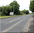
A483 from Builth Wells reaches Llandrindod Wells
The A483, here named Wellington Road, passes the Llandrindod Wells boundary sign. http://www.geograph.org.uk/photo/3538007
Image: © Jaggery Taken: 30 Jun 2013
0.11 miles
5
Pentrosfa houses, Llandrindod Wells
Houses on the north side of Pentrosfa viewed from the A483 Wellington Road end looking towards Pentrosfa Crescent.
Image: © Jaggery Taken: 30 Jun 2013
0.12 miles
6
Heart of Wales railway, Llandrindod Wells
A view south from this http://www.geograph.org.uk/photo/3538256 bridge. The next station ahead is Builth Road. Llandrindod Wells station is 1.3km behind the camera.
Image: © Jaggery Taken: 30 Jun 2013
0.13 miles
7
A483 at southern end of Llandrindod Wells
Taken from Pentrosfa junction
Image: © John Firth Taken: 7 Sep 2012
0.13 miles
8
Marshland near Howey
Image: © toby everard Taken: 5 Apr 2008
0.15 miles
9
Wellington Road
Image: © David Dixon Taken: 14 Apr 2016
0.16 miles
10
Wellington Road, Pentrosfa
Image: © Colin Pyle Taken: 6 Jan 2011
0.17 miles