
IMAGES TAKEN NEAR TO
Natland, KENDAL, LA9 7QB
Introduction
This page details the photographs taken nearby to LA9 7QB by members of the Geograph project.
The Geograph project started in 2005 with the aim of publishing, organising and preserving representative images for every square kilometre of Great Britain, Ireland and the Isle of Man.

There are currently over 7.5m images from over14,400 individuals and you can help contribute to the project by visiting https://www.geograph.org.uk
Image Map
Images are licensed for reuse under creativecommons.org/licenses/by-sa/2.0
Notes
- Clicking on the map will re-center to the selected point.
- The higher the marker number, the further away the image location is from the centre of the postcode.
Image Listing (21 Images Found)
Images are licensed for reuse under creativecommons.org/licenses/by-sa/2.0
Image
Details
Distance
1
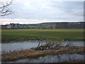
Watercrook Farm and the River Kent
A view from the north bank of the farm with the flat platform of the Roman fort http://www.archaeologyuk.org/lahs/Contrebis/25_6_Shotter.pdf of Alavana (or Alone or Alunna) extending away to the right.
Image: © Karl and Ali
Taken: 5 Jan 2014
0.02 miles
2

Road to Watercrook Farm
Our route turned left here on a footpath over the fields to follow the River Kent south
Image: © Martin Dawes
Taken: 22 May 2012
0.03 miles
3
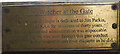
Memorial plaque near Watercrook Farm
Dedicated to Jim Parkin 'secretary to KAA for in excess of thirty years'. Fixed to a gate allowing anglers access to the River Kent.
Image: © Karl and Ali
Taken: 25 Oct 2015
0.07 miles
4

Watercrook Farm and the River Kent
The river is leaving the town of Kendal. The grass to the right is the site of a Roman fort, but only some of the contours are now visible.
Image: © Bill Boaden
Taken: 28 Feb 2014
0.08 miles
5

Watercrook Roman fort (Alauna)
There is very little visible today of the fort http://www.archaeologyuk.org/lahs/Contrebis/25_6_Shotter.pdf Its rampart can be seen where the low drystone wall ascends a very slight rise.
Image: © Karl and Ali
Taken: 25 Oct 2015
0.09 miles
6

Foam blow-hole by the River Kent
I was a bit perturbed to find this by the path. It was actively spewing out pink foam. I imagine it must be linked to the sewage works close by.
Image: © Bill Boaden
Taken: 28 Feb 2014
0.09 miles
8

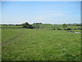
Scroggs Weir
The first obstacle on a descent of the River Kent from Kendal is Scroggs Weir. Even when there is enough water to make the rest of the river a pleasant trip, this weir is wide that the water is shallow and a slide down the face of the weir is a bumpy experience. The water is deepest at the far left, but awkward rocks lie in wait below.
Image: © Andy Waddington
Taken: 3 Nov 2007
0.12 miles
9

Waste Water Treatment Works, Kendal
This is a large site which occupies a large bend of the river.
Image: © Bill Boaden
Taken: 28 Feb 2014
0.12 miles
10

Channel in Scroggs Weir, River Kent
There is little water in the river today and the flow over most of the weir is very shallow. Perhaps this channel was cut to help migrating salmon and trout pass upstream?
Image: © Karl and Ali
Taken: 25 Oct 2015
0.12 miles