
IMAGES TAKEN NEAR TO
Ghyll Side, KENDAL, LA9 5DW
Introduction
This page details the photographs taken nearby to Ghyll Side, LA9 5DW by members of the Geograph project.
The Geograph project started in 2005 with the aim of publishing, organising and preserving representative images for every square kilometre of Great Britain, Ireland and the Isle of Man.

There are currently over 7.5m images from over14,400 individuals and you can help contribute to the project by visiting https://www.geograph.org.uk
Image Map
Images are licensed for reuse under creativecommons.org/licenses/by-sa/2.0
Notes
- Clicking on the map will re-center to the selected point.
- The higher the marker number, the further away the image location is from the centre of the postcode.
Image Listing (117 Images Found)
Images are licensed for reuse under creativecommons.org/licenses/by-sa/2.0
Image
Details
Distance

2

Former Inghamite Chapel, Bankfield Road, Kendal
The English Heritage on-line thesaurus defines an Inghamite chapel as one for followers of Benjamin Ingham after he left the Moravians prior to joining the Sandamanians. Benjamin Ingham was a Yorkshire preacher in the mid 1700s and toured Yorkshire and Lancashire after being ordained in 1735. His followers established around 100 chapels at the height of his popularity, but only two are still in use, at Wheatley Lane and at Salterforth, both in the Pendle area of Lancashire. He died in 1772. The Kendal chapel was built in 1844 in the then old-fashioned late Georgian style with round-arched windows and a pedimented front. It has been converted to flats.
Image: © Humphrey Bolton
Taken: 7 May 2006
0.02 miles
3

Summerhill care home, Captain French Lane, Kendal
This is part of a very extensive building, dated 1996 on the circular plaque under the gable on the left.
Image: © Humphrey Bolton
Taken: 7 May 2006
0.02 miles
4

Benchmark on Playmates Daycare & Preschool
Further information on the Ordnance Survey cut mark benchmark on the Gillinggate face of the Daycare Centre may be found on the Bench Mark Database at http://www.bench-marks.org.uk/bm34986 . A photo showing how the mark has weathered in the 12 years since this photo was taken is at Image
Image: © Roger Templeman
Taken: 28 Jul 2010
0.02 miles
5

Benchmark on Gillinggate face of building at Captain French Lane junction
Ordnance Survey cut mark benchmark levelled at 80.260m above Newlyn Datum verified 1971
Image: © Roger Templeman
Taken: 23 Jul 2022
0.02 miles
6

Former clinic at Gillinggate / Captain French Lane junction
There is an Ordnance Survey benchmark Image on the near corner of the building left of the Gillinggate road name sign.
Image: © Roger Templeman
Taken: 23 Jul 2022
0.02 miles
7

Ordnance Survey Cut Mark
This OS cut mark can be found at the junction of Gillinggate & Captain French Lane It marks a point 80.260m above mean sea level.
Image: © Adrian Dust
Taken: 22 Oct 2023
0.02 miles
8
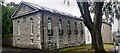
Chapel Court on NE side of Bankfield Road
Former Inghamite Chapel with two Ordnance Survey benchmarks Image on its near corner. The one on the right hand face was levelled at 84.950m above Newlyn Datum and verified in 1973: the one on the left hand face is cancelled
Image: © Roger Templeman
Taken: 23 Jul 2022
0.03 miles
9

Former clinic on Gillinggate
Ordnance Survey records indicate that a benchmark levelled at 79.190m above Newlyn Datum was verified in 1971 on the front of the building at its left hand corner
Image: © Roger Templeman
Taken: 25 Nov 2023
0.03 miles
10

Benchmarks on former Inghamite Chapel
There are two Ordnance Survey cut mark benchmarks on this former church. One is cancelled (indicated by the extension of the side arrow cuts through the datum (horizontal) cut. The other is described in more detail on the Bench Mark Database at http://www.bench-marks.org.uk/bm34985.
Image: © Roger Templeman
Taken: 28 Jul 2010
0.04 miles