
IMAGES TAKEN NEAR TO
Lowther Street, KENDAL, LA9 4UF
Introduction
This page details the photographs taken nearby to Lowther Street, LA9 4UF by members of the Geograph project.
The Geograph project started in 2005 with the aim of publishing, organising and preserving representative images for every square kilometre of Great Britain, Ireland and the Isle of Man.

There are currently over 7.5m images from over14,400 individuals and you can help contribute to the project by visiting https://www.geograph.org.uk
Image Map
Images are licensed for reuse under creativecommons.org/licenses/by-sa/2.0
Notes
- Clicking on the map will re-center to the selected point.
- The higher the marker number, the further away the image location is from the centre of the postcode.
Image Listing (436 Images Found)
Images are licensed for reuse under creativecommons.org/licenses/by-sa/2.0
Image
Details
Distance
1
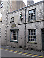
Gawith, Hoggarth snuff blenders, Kendal
This building has been associated with tobacco and snuff since the 1830s and the Gawith family moved in in 1841. It was a factory for Gawith, Hoggarth from 1887 until 1994 and was lying empty when seen in 2018. It is now undergoing renovation with plans to turn it into a small shop and museum about the Kendal tobacco industry, to house some offices for the current company and make two apartments above as well as a Bistro in the old machinery shed. When seen in 2023 the Saracen or Turk had been removed for restoration but it is intended that he will return.
Image: © Chris Allen
Taken: 19 Sep 2018
0.02 miles
2
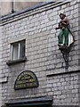
Gawith, Hoggarth snuff blenders, Kendal
This Grade II Listed building has been associated with tobacco and snuff since the 1830s and the Gawith family moved in in 1841. It was a factory for Gawith, Hoggarth from 1887 until 1994 and was lying empty when seen in 2018. It is now undergoing renovation with plans to turn it into a small shop and museum about the Kendal tobacco industry, to house some offices for the current company and make two apartments above as well as a Bistro in the old machinery shed. When seen in 2023 the Saracen or Turk had been removed for restoration but it is intended that he will return.
Image: © Chris Allen
Taken: 19 Sep 2018
0.02 miles
3
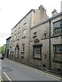
Gawith, Hoggarth snuff blenders, Kendal
This Grade II Listed building has been associated with tobacco and snuff since the 1830s and the Gawith family moved in in 1841. It was a factory for Gawith, Hoggarth from 1887 until 1994 and was lying empty when seen in 2018. It is now undergoing renovation with plans to turn it into a small shop and museum about the Kendal tobacco industry, to house some offices for the current company and make two apartments above as well as a Bistro in the old machinery shed. When seen in 2023 the Saracen or Turk had been removed from its wall bracket for restoration, but it is intended that he will return.
Image: © Chris Allen
Taken: 25 Sep 2023
0.02 miles
4
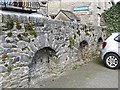
Bee boles in Dowker Lane Car Park
Bee boles are alcoves in a wall where straw bee skeps were placed for protection against the elements.
The examples here were originally in a garden, and the ground level may have been raised when the car park was surfaced. They probably each had a shelf inside (see entry in the Bee Boles Register created by the International Bee Research Association http://ibra.beeboles.org.uk/search_detail.php?beeboleIBRARegNo=0670 ).
This wall with bee boles, probably dating from the early 19th century, is Grade II listed - see Images of England http://www.imagesofengland.org.uk/details/default.aspx?id=75527 .
Tanners Yard is behind the wall.
Image: © Rose and Trev Clough
Taken: 19 Apr 2016
0.02 miles
7
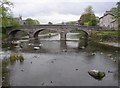
Miller Bridge, Kendal
Built in 1818.
Image: © Humphrey Bolton
Taken: 7 May 2006
0.04 miles
10
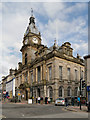
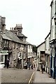
Kendal Town Hall
The town hall at the corner of Lowther Street/Highgate (A6).
Image: © David Dixon
Taken: 11 Feb 2013
0.04 miles