
IMAGES TAKEN NEAR TO
Windermere Road, KENDAL, LA9 4QU
Introduction
This page details the photographs taken nearby to Windermere Road, LA9 4QU by members of the Geograph project.
The Geograph project started in 2005 with the aim of publishing, organising and preserving representative images for every square kilometre of Great Britain, Ireland and the Isle of Man.

There are currently over 7.5m images from over14,400 individuals and you can help contribute to the project by visiting https://www.geograph.org.uk
Image Map
Images are licensed for reuse under creativecommons.org/licenses/by-sa/2.0
Notes
- Clicking on the map will re-center to the selected point.
- The higher the marker number, the further away the image location is from the centre of the postcode.
Image Listing (88 Images Found)
Images are licensed for reuse under creativecommons.org/licenses/by-sa/2.0
Image
Details
Distance
1

Benchmark on east angle of #14 Windermere Road
Ordnance Survey cut mark benchmark levelled at 62.627m above Newlyn Datum verified 1971
Image: © Roger Templeman
Taken: 8 Jun 2024
0.04 miles
2

Ordnance Survey Cut Mark
This OS cut mark can be found on No26 Union Street. It marks a point 53.870m above mean sea level.
Image: © Adrian Dust
Taken: 26 Oct 2023
0.04 miles
3

Looking west-northwest up Windermere Road
Image: © Basher Eyre
Taken: 16 Feb 2015
0.04 miles
4

Houses on Windermere Road
There is an Ordnance Survey benchmark Image on the near corner, road face, of the nearest house on the left hand side of the road
Image: © Roger Templeman
Taken: 8 Jun 2024
0.04 miles
5

Ordnance Survey Cut Mark
This OS cut mark can be found on No14 Windermere Road. It marks a point 62.627m above mean sea level.
Image: © Adrian Dust
Taken: 26 Oct 2023
0.05 miles

7

Ordnance Survey Cut Mark
This OS cut mark can be found on No3 Windermere Road. It marks a point 52.996m above mean sea level.
Image: © Adrian Dust
Taken: 26 Oct 2023
0.05 miles

9
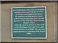
Plaque at Stricklandgate Methodist Church, Kendal
This photo shows the plaque which is fixed to the front of Stricklandgate Methodist Church on the A591 Windermere Road LA9 4QJ. It says the following:
Revd John Wesley MA first preached in
Kendal on Monday 9th April 1753
in a large convenient room where
Mr Ingham's society used to meet.
A Methodist society was later formed
and met in the Old Play House in the
Market Place.
Later the society moved to The Fold
in Stricklandgate and then into a new
chapel on this site in 1808. This present
chapel opened on Thursday 29th March
1883.
Image: © David Hillas
Taken: 24 Jul 2017
0.06 miles
10
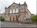
Stricklandgate Methodist Church, Kendal
Situated on the A591 Windermere Road LA9 4QJ at the junction with Burneside Road, this Church dates from 1882 although the previous chapel on this site dates from 1808. It is one of nine Churches in the Kendal Methodist Circuit. Service are held here each Sunday at 10.30am and at 6.30pm on the third Sunday of each month, except during the Winter months when it is 4.30pm.
Image: © David Hillas
Taken: 24 Jul 2017
0.06 miles