
IMAGES TAKEN NEAR TO
Stricklandgate, KENDAL, LA9 4NE
Introduction
This page details the photographs taken nearby to Stricklandgate, LA9 4NE by members of the Geograph project.
The Geograph project started in 2005 with the aim of publishing, organising and preserving representative images for every square kilometre of Great Britain, Ireland and the Isle of Man.

There are currently over 7.5m images from over14,400 individuals and you can help contribute to the project by visiting https://www.geograph.org.uk
Image Map
Images are licensed for reuse under creativecommons.org/licenses/by-sa/2.0
Notes
- Clicking on the map will re-center to the selected point.
- The higher the marker number, the further away the image location is from the centre of the postcode.
Image Listing (415 Images Found)
Images are licensed for reuse under creativecommons.org/licenses/by-sa/2.0
Image
Details
Distance

2

Information board, Wainwright's Yard, Kendal
The following text is included,
"WAINWRIGHT'S YARD
Alfred Wainwright was born in Blackburn
in 1907, becoming Kendal's Borough
Treasurer in 1948. He loved maps and
in 1930 visited the Lake District where
his life was dramatically changed.
In 1955 he published the first of his
famous 'Pictorial Guides to the Lakeland
Fells'. The text was written in his
characteristic, clear hand which was
augmented by meticulous maps and
sketches. The books were printed, and
later published, by 'The Westmorland
Gazette' in Kendal, selling over one
million copies.
For some years he was curator of Kendal
Museum. In 1984 he opened 'Kapelian'as
headquarters of Animal Rescue Cumbria.
He died in 1991.
KENDAL CIVIC SOCIETY"
Image: © Kenneth Allen
Taken: 18 Apr 2013
0.01 miles
3

Post Office, Kendal
It is the building on the right
Image: © Kenneth Allen
Taken: 18 Apr 2013
0.01 miles

5
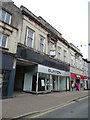
Former Burton's shop on Stricklandgate, Kendal
Image: © JThomas
Taken: 2 Jul 2021
0.01 miles

7
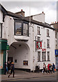
Former Woolpack Inn, Kendal
Built in 1791 (although there is evidence of an earlier building dating from 1695), the Inn and adjoining hotel closed in the late 1990s, with the modern hotel buildings later demolished. One of Kendal's oldest buildings, it is now a fast food outlet.
More information on the Woolpack Inn may be found: http://www.visitcumbria.com/sl/kendal-woolpack/
Photograph is for record only. I have no connection with this business and am unable to advise on its products or services.
Image: © The Carlisle Kid
Taken: 16 May 2015
0.01 miles
8

Market Place & War memorial
Image: © Nick Mutton 01329 000000
Taken: 17 May 2008
0.02 miles
9
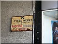
Old enamel sign - K Cycle Works
Located in Redmayne's (formerly Redman's) Yard, beside Burton's in Stricklandgate.
The cycle works and dealership was behind the main street. It is long gone, but a couple of old photos showing the bicycles stacked in the yard can be seen in 'Centuries of cycling' by Cumbria Archives Service http://www.cumbria.gov.uk/eLibrary/Content/Internet/542/795/4152616230.pdf .
Image: © Rose and Trev Clough
Taken: 19 Apr 2016
0.02 miles
10

Kendal - Farrers Tea & Coffee Shop, Stricklandgate
Image: © Colin Park
Taken: 25 Jul 2018
0.02 miles