IMAGES TAKEN NEAR TO
Whinfell, KENDAL, LA8 9EG
Introduction
This page details the photographs taken nearby to LA8 9EG by members of the Geograph project.
The Geograph project started in 2005 with the aim of publishing, organising and preserving representative images for every square kilometre of Great Britain, Ireland and the Isle of Man.

There are currently over 7.5m images from over14,400 individuals and you can help contribute to the project by visiting https://www.geograph.org.uk
Image Map
Images are licensed for reuse under creativecommons.org/licenses/by-sa/2.0
Notes
- Clicking on the map will re-center to the selected point.
- The higher the marker number, the further away the image location is from the centre of the postcode.
Image Listing (4 Images Found)
Images are licensed for reuse under creativecommons.org/licenses/by-sa/2.0
Image
Details
Distance
1
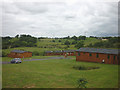
Holiday cabins at Topthorn
Looking over the rolling countryside of the Mint valley.
Image: © Karl and Ali
Taken: 28 Jun 2014
0.09 miles
2
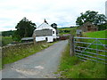
Howestone
Drive entrance from the road running north south
Image: © William Bartlett
Taken: 9 Jul 2007
0.16 miles
3
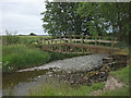
Footbridge over the River Mint
The load-bearing frame is made from a steel girder construction. The Mint is a trickle today but debris wedged in the frame demonstrates that the river can rise that far and overflow into the fields.
Image: © Karl and Ali
Taken: 28 Jun 2014
0.17 miles
4
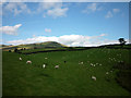
Sheep grazing by Whinfell Tarn
All the sheep in this pasture look like this year's lambs. Whinfell Beacon beyond.
Image: © Karl and Ali
Taken: 2 Sep 2012
0.23 miles