
IMAGES TAKEN NEAR TO
St. Anthonys Close, MILNTHORPE, LA7 7DT
Introduction
This page details the photographs taken nearby to St. Anthonys Close, LA7 7DT by members of the Geograph project.
The Geograph project started in 2005 with the aim of publishing, organising and preserving representative images for every square kilometre of Great Britain, Ireland and the Isle of Man.

There are currently over 7.5m images from over14,400 individuals and you can help contribute to the project by visiting https://www.geograph.org.uk
Image Map
Images are licensed for reuse under creativecommons.org/licenses/by-sa/2.0
Notes
- Clicking on the map will re-center to the selected point.
- The higher the marker number, the further away the image location is from the centre of the postcode.
Image Listing (9 Images Found)
Images are licensed for reuse under creativecommons.org/licenses/by-sa/2.0
Image
Details
Distance
1

Barn in Milnthorpe
In grassland north of the town centre.
Image: © philandju
Taken: 28 Aug 2015
0.04 miles
2

St Anthony's Tower
The Summer House built to commemorate the reform bill of 1832
Image: © Paul Brooker
Taken: 10 Aug 2009
0.10 miles
3

St Anthony's Tower
Zoom shot from the lane near Haverbrack with the Howgill Fells beyond. There is no public access to the tower.
Image: © Karl and Ali
Taken: 11 Dec 2010
0.14 miles
4

St Anthony's Tower
A zoom shot from the A6 just north of Milnthorpe. The tower sits on a drumlin at about 69m asl and is a prominent local landmark. There are no public rights of way to reach it but maybe the locals know a way .......
Image: © Karl and Ali
Taken: 25 Jan 2012
0.15 miles
5

St Anthony's Tower
Viewed from near the A6
Image: © Kevin Waterhouse
Taken: 10 Oct 2018
0.15 miles

7

Leaving Milnthorpe
Heading north on the A6. The speed restriction changes here from 30 mph to 50 mph.
Image: © Mary and Angus Hogg
Taken: 26 Apr 2022
0.23 miles
8
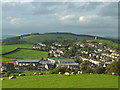
Milnthorpe from the Dallam deer park earthwork
A zoom shot from the edge of the earthwork showing the recent developments (including a soon-to-be-opened Booth's supermarket) west of the A6. St Anthony's Tower Image is prominent just north with Heversham Head (123m) beyond.
Image: © Karl and Ali
Taken: 22 Aug 2012
0.23 miles
9
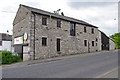
The Red Barn, Milnthorpe
The history of this barn is given on a plaque - see Image .
It is now occupied by a flooring contractor.
Image: © Ian Taylor
Taken: 31 May 2010
0.24 miles