
IMAGES TAKEN NEAR TO
Badger Wood, MORECAMBE, LA3 3FJ
Introduction
This page details the photographs taken nearby to Badger Wood, LA3 3FJ by members of the Geograph project.
The Geograph project started in 2005 with the aim of publishing, organising and preserving representative images for every square kilometre of Great Britain, Ireland and the Isle of Man.

There are currently over 7.5m images from over14,400 individuals and you can help contribute to the project by visiting https://www.geograph.org.uk
Image Map
Images are licensed for reuse under creativecommons.org/licenses/by-sa/2.0
Notes
- Clicking on the map will re-center to the selected point.
- The higher the marker number, the further away the image location is from the centre of the postcode.
Image Listing (10 Images Found)
Images are licensed for reuse under creativecommons.org/licenses/by-sa/2.0
Image
Details
Distance
1

Middleton Tower Holiday Camp
No longer a holiday destination surprising as not too many holiday camps have a Nuclear Power Station right next door (visible behind the trees).
Image: © Michael Graham
Taken: 15 Dec 2005
0.13 miles
2

Middleton Tower
The hydraulic excavator visible to the north seems to be demolishing the former holiday camp here.
Image: © David Long
Taken: 22 Feb 2006
0.13 miles
3
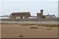
Middleton Tower and Farm
The tower and the barn (to its left) and the farmhouse (behind the tower) are all Grade II listed buildings.
The tower (Historic England List Entry Number: 1164309 https://historicengland.org.uk/listing/the-list/list-entry/1164309 ) was a folly, probably built in the early nineteenth century. The barn (Historic England List Entry Number: 1071771 https://historicengland.org.uk/listing/the-list/list-entry/1071771 ) dates from the eighteenth century; the farmhouse (Historic England List Entry Number: 1071770 https://historicengland.org.uk/listing/the-list/list-entry/1071770 ) was built in the seventeenth century (and altered in 1844).
The buildings were adapted for use as part of the Pontins Holiday Camp which operated here between 1939 and 1994.
Image: © David Dixon
Taken: 25 May 2019
0.14 miles
4

Middleton Tower
Previously within Pontins holiday camp, now part of Middleton Towers retirement village.
Pevsner says that the tower is probably early C19, its origin and associations seem to be unknown. English Heritage describes it as a folly.
It is a Grade II Listed Building - https://historicengland.org.uk/listing/the-list/list-entry/1164309 .
Image: © Ian Taylor
Taken: 17 Aug 2011
0.15 miles


7

Middleton Sands
In the background are Heysham Power Station (left) and Middleton Tower (right of centre).
Image: © Ian Taylor
Taken: 17 Aug 2011
0.24 miles

9

Middleton Sands
Middleton Tower is in the background.
Image: © Ian Taylor
Taken: 17 Aug 2011
0.25 miles
10

Ocean Edge holiday park
Vacant plot in the foreground.
Image: © Ian Taylor
Taken: 16 Jun 2011
0.25 miles