IMAGES TAKEN NEAR TO
Main Street, MILLOM, LA19 5TF
Introduction
This page details the photographs taken nearby to Main Street, LA19 5TF by members of the Geograph project.
The Geograph project started in 2005 with the aim of publishing, organising and preserving representative images for every square kilometre of Great Britain, Ireland and the Isle of Man.

There are currently over 7.5m images from over14,400 individuals and you can help contribute to the project by visiting https://www.geograph.org.uk
Image Map
Images are licensed for reuse under creativecommons.org/licenses/by-sa/2.0
Notes
- Clicking on the map will re-center to the selected point.
- The higher the marker number, the further away the image location is from the centre of the postcode.
Image Listing (43 Images Found)
Images are licensed for reuse under creativecommons.org/licenses/by-sa/2.0
Image
Details
Distance
4
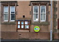
Defibrillator on Captain Shaw's C of E School, Bootle
See Image] for context.
Image: © JThomas
Taken: 16 Nov 2019
0.04 miles
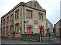
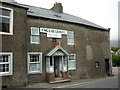
6
Captain Shaw's C of E School, Bootle
On Main Street.
Image: © JThomas
Taken: 16 Nov 2019
0.04 miles
8
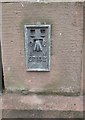
Ordnance Survey Flush Bracket (S7102)
This OS Flush Bracket can be found on the school. It marks a point 27.987m above mean sea level.
Image: © Adrian Dust
Taken: 9 Jun 2016
0.05 miles
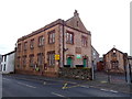
9
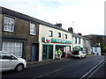
Bottle Stores and Post Office
On Main Street.
Image: © JThomas
Taken: 16 Nov 2019
0.05 miles
