
IMAGES TAKEN NEAR TO
Grammerscroft, MILLOM, LA18 5EL
Introduction
This page details the photographs taken nearby to Grammerscroft, LA18 5EL by members of the Geograph project.
The Geograph project started in 2005 with the aim of publishing, organising and preserving representative images for every square kilometre of Great Britain, Ireland and the Isle of Man.

There are currently over 7.5m images from over14,400 individuals and you can help contribute to the project by visiting https://www.geograph.org.uk
Image Map
Images are licensed for reuse under creativecommons.org/licenses/by-sa/2.0
Notes
- Clicking on the map will re-center to the selected point.
- The higher the marker number, the further away the image location is from the centre of the postcode.
Image Listing (8 Images Found)
Images are licensed for reuse under creativecommons.org/licenses/by-sa/2.0
Image
Details
Distance


3
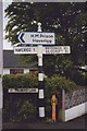
Old Direction Sign - Signpost by the A5093, Palmers Lane, Millom Without Parish
Pawn finial - 2 arms; Cumberland CC square end, by the A5093, in parish of Millom Without (Copeland District), Haverigg, Palmers Lane opposite Moor Terrace.
Surveyed
Milestone Society National ID: CU_SD1679.
Image: © Milestone Society
Taken: Unknown
0.18 miles
4
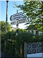
Pre-Worboys roadsign near Millom
If you ignore the modern pointer to the prison, it's otherwise a fine example of a pre-Worboys road marker. Sir Walter Worboys chaired a Government Committee, formed in 1963, which led to the development of standardised signage across the country, and which when implemented, saw the removal of many of these older black and white signs.
Image: © Richard Law
Taken: 21 May 2014
0.18 miles
5
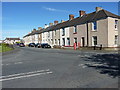
Moor Road and Palmers Lane junction
The row of houses is Moor Terrace
Image: © Richard Law
Taken: 21 May 2014
0.20 miles
6
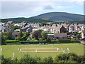
Millom cricket ground and Holborn Hill, Black Combe behind
Taken from beside the Cumbrian coast railway line.
Image: © Andrew Hill
Taken: 30 May 2006
0.22 miles
8
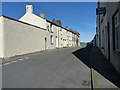
Holborn Hill, Millom
The line and width of this road through the town rather suggests it may have been the original (coaching?) route, now superseded by the modern A5093.
Image: © Richard Law
Taken: 21 May 2014
0.25 miles