
IMAGES TAKEN NEAR TO
Juniper Close, DALTON-IN-FURNESS, LA15 8TB
Introduction
This page details the photographs taken nearby to Juniper Close, LA15 8TB by members of the Geograph project.
The Geograph project started in 2005 with the aim of publishing, organising and preserving representative images for every square kilometre of Great Britain, Ireland and the Isle of Man.

There are currently over 7.5m images from over14,400 individuals and you can help contribute to the project by visiting https://www.geograph.org.uk
Image Map
Images are licensed for reuse under creativecommons.org/licenses/by-sa/2.0
Notes
- Clicking on the map will re-center to the selected point.
- The higher the marker number, the further away the image location is from the centre of the postcode.
Image Listing (66 Images Found)
Images are licensed for reuse under creativecommons.org/licenses/by-sa/2.0
Image
Details
Distance
1

Ordnance Survey Cut Mark
This OS cut mark can be found on a gatepost south side of Holly Gate Lane. It marks a point 42.439m above mean sea level.
Image: © Adrian Dust
Taken: 15 Oct 2019
0.04 miles


4

Dalton Railway Station Building
Dalton railway station, which serves the town of Dalton-in-Furness, was first opened to passengers on 24 August 1846. It is located on the Furness Line from Barrow-in-Furness to Lancaster. Today, it is owned by Network Rail and is operated by Northern who provide all passenger train services.
Image: © David Dixon
Taken: 27 Aug 2020
0.07 miles
5

Dalton railway station, Cumbria
Opened in 1846 by the Furness Railway on the line which now joins Lancaster with Barrow-in-Furness. View south west towards Furness Abbey and Barrow.
From old maps, there used to be a goods line round the back of the platform on the left, and a goods shed beyond the station building on the right.
Image: © Nigel Thompson
Taken: 13 Jul 2013
0.07 miles

7

Dalton War Memorial
This picture was taken from the roadside near to Dalton Police Station
Image: © Lee Coward
Taken: 1 Jan 2006
0.08 miles
8

Dalton-in-Furness Railway Station
The railway station building on Station Approach, Dalton.
Image: © Graham Robson
Taken: 3 Nov 2014
0.08 miles
9

The War Memorial, Station Road, Dalton-in-Furness
Dalton’s War memorial was unveiled 25 May 1922. It is made of Portland limestone and comprises a square plinth with diagonal buttresses surmounted by a square column with moulded capital and a carved eternal flame with a sword on the front face. The plinth bears the dedication to men of Dalton lost in the Great War, their names are on bronze plaques to left and right sides.
It is Grade II-listed (https://historicengland.org.uk/listing/the-list/list-entry/1218879 Historic England List Entry Number: 1218879).
Image: © David Dixon
Taken: 27 Aug 2020
0.09 miles
10
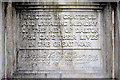
Dedication on Dalton War Memorial
Dedication on Image
ERECTED IN GRATEFUL
AND UNFADING MEMORY
OF THE MEN OF DALTON
WHO GAVE THEIR LIVES
IN THE GREAT WAR
"O IF THOU WEEP,
SUCH COURAGE AND HONOUR, BEAUTY, CARE,
BE IT FOR JOY THAT THOSE WHO SLEEP
ONLY THY JOY COULD SHARE"
The quotation is from the poem "How Sleep the Brave" by Walter de la Mare.
Image: © David Dixon
Taken: 27 Aug 2020
0.09 miles