
IMAGES TAKEN NEAR TO
Ulverston Road, DALTON-IN-FURNESS, LA15 8EY
Introduction
This page details the photographs taken nearby to Ulverston Road, LA15 8EY by members of the Geograph project.
The Geograph project started in 2005 with the aim of publishing, organising and preserving representative images for every square kilometre of Great Britain, Ireland and the Isle of Man.

There are currently over 7.5m images from over14,400 individuals and you can help contribute to the project by visiting https://www.geograph.org.uk
Image Map
Images are licensed for reuse under creativecommons.org/licenses/by-sa/2.0
Notes
- Clicking on the map will re-center to the selected point.
- The higher the marker number, the further away the image location is from the centre of the postcode.
Image Listing (42 Images Found)
Images are licensed for reuse under creativecommons.org/licenses/by-sa/2.0
Image
Details
Distance
1

Ordnance Survey Cut Mark
This OS cut mark can be found on the corner of the school wall, Ulverston Road. It marks a point 40.443m above mean sea level.
Image: © Adrian Dust
Taken: 15 Oct 2019
0.02 miles
2

Our Lady of the Rosary & St Margaret of Scotland, Sign
Image: © Alexander P Kapp
Taken: 17 Aug 2005
0.03 miles
3

Our Lady of the Rosary & St Margaret of Scotland
Image: © Alexander P Kapp
Taken: 17 Aug 2005
0.04 miles
4
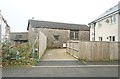
Old building near the junction of Yarl Well and Ulverston Road
Image: © Stephen Middlemiss
Taken: 31 Oct 2014
0.05 miles
5

Ordnance Survey Flush Bracket (S7108)
This OS Flush Bracket can be found on the NW angle of St Margaret's Church. It marks a point 40.769m above mean sea level.
Image: © Adrian Dust
Taken: 15 Oct 2019
0.05 miles
6

The Clarence Inn, Ulverston Road, Dalton
The public house on a street corner in Dalton. The pub appears to be closed, but the building is grade II listed.
Image: © Graham Robson
Taken: 3 Nov 2014
0.08 miles
7
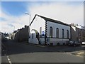
Seventh Day Adventist Church, Dalton-in-Furness
The church of the Seventh Day Adventists in Dalton is in a building which was formerly a Methodist church built in 1868. The building is grade II listed. Link to the building's page on the British Listed Buildings website here: http://www.britishlistedbuildings.co.uk/en-388627-seventh-day-adventist-church-with-attach
Image: © Graham Robson
Taken: 3 Nov 2014
0.09 miles
8

Ordnance Survey Cut Mark
This OS cut mark can be found on the east angle of the Church of Christ. It marks a point 40.917m above mean sea level.
Image: © Adrian Dust
Taken: 15 Oct 2019
0.09 miles
9
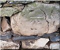
Ordnance Survey Cut Mark
This OS cut mark can be found on the wall NW side of Ulverston Road. It marks a point 44.894m above mean sea level.
Image: © Adrian Dust
Taken: 15 Oct 2019
0.10 miles
10

Seventh-day Adventist Church, Barrow, Sign
Image: © Alexander P Kapp
Taken: 17 Aug 2005
0.11 miles