
IMAGES TAKEN NEAR TO
Braddyll Terrace, ULVERSTON, LA12 0DH
Introduction
This page details the photographs taken nearby to Braddyll Terrace, LA12 0DH by members of the Geograph project.
The Geograph project started in 2005 with the aim of publishing, organising and preserving representative images for every square kilometre of Great Britain, Ireland and the Isle of Man.

There are currently over 7.5m images from over14,400 individuals and you can help contribute to the project by visiting https://www.geograph.org.uk
Image Map
Images are licensed for reuse under creativecommons.org/licenses/by-sa/2.0
Notes
- Clicking on the map will re-center to the selected point.
- The higher the marker number, the further away the image location is from the centre of the postcode.
Image Listing (164 Images Found)
Images are licensed for reuse under creativecommons.org/licenses/by-sa/2.0
Image
Details
Distance
1

Ordnance Survey Cut Mark
This OS cut mark can be found on the step of No12 Braddyl Terrace. It marks a point 23.776m above mean sea level.
Image: © Adrian Dust
Taken: 17 Oct 2019
0.02 miles
2
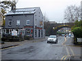
Devonshire Arms pub, Ulverston
The Devonshire Arms pub on Victoria Road Ulverston. The bridge behind the pub carries the main railway line serving the cumbrian coast over the road. Ulverston station is some distance along the line to the left.
Image: © Graham Robson
Taken: 9 Nov 2012
0.03 miles
3
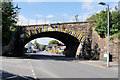
Victoria Road Railway Bridge, Ulverston
Image: © David Dixon
Taken: 23 Aug 2020
0.04 miles
4
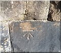
Ordnance Survey Cut Mark
This OS cut mark can be found on the NE abutment of Victoria Road Railway Bridge. It marks a point 19.114m above mean sea level.
Image: © Adrian Dust
Taken: 17 Oct 2019
0.04 miles
5

Ordnance Survey Cut Mark
This OS cut mark can be found at the junction of Victoria Road & Lightburn Avenue. It marks a point 18.220m above mean sea level.
Image: © Adrian Dust
Taken: 17 Oct 2019
0.04 miles
6
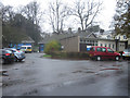
Ulverston Ambulance Station
The base for ambulances serving Ulverston and the surrounding area.
Image: © Graham Robson
Taken: 9 Nov 2012
0.05 miles
7
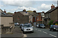
Ulverston, Cumbria
Looking down Brogden Street, towards the distant Hoad Hill Monument.
Image: © Peter Trimming
Taken: 8 Jul 2014
0.06 miles
9
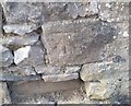
Ordnance Survey Cut Mark
This OS cut mark can be found on the wall SW side of Brogden Street. It marks a point 19.126m above mean sea level.
Image: © Adrian Dust
Taken: 17 Oct 2019
0.07 miles
10
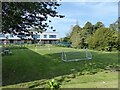
Todbusk lawn
Formerly the rear lawn of Todbusk, a large private house built for Barrow iron foundry owner David Caird, this old lawn has raised edges which enabled it to be flooded with shallow water in winter to create an ice rink.
The Sandside Lodge School building in the background stands just beyond where Todbusk used to stand overlooking the lawn and garden. Todbusk became the offices of Ulverston Urban District Council which was abolished on Local Government Reorganisation in 1974 and after a further period of local authority use it was demolished to make way for the Sandside Lodge School building, a facility for children with special educational needs.
Image: © Adrian Taylor
Taken: 8 Sep 2021
0.08 miles