
IMAGES TAKEN NEAR TO
Cartmel Fell, GRANGE-OVER-SANDS, LA11 6NG
Introduction
This page details the photographs taken nearby to LA11 6NG by members of the Geograph project.
The Geograph project started in 2005 with the aim of publishing, organising and preserving representative images for every square kilometre of Great Britain, Ireland and the Isle of Man.

There are currently over 7.5m images from over14,400 individuals and you can help contribute to the project by visiting https://www.geograph.org.uk
Image Map
Images are licensed for reuse under creativecommons.org/licenses/by-sa/2.0
Notes
- Clicking on the map will re-center to the selected point.
- The higher the marker number, the further away the image location is from the centre of the postcode.
Image Listing (8 Images Found)
Images are licensed for reuse under creativecommons.org/licenses/by-sa/2.0
Image
Details
Distance
1

Cows at Swallow Mire
Whitbarrow Scar across the Winster Valley.
Image: © Karl and Ali
Taken: 18 May 2012
0.09 miles

3

Footbridge over the River Winster near Swallow Mire
The monument on Raven's Barrow http://www.geograph.org.uk/photo/2378060 can just be seen on the skyline above.
Image: © Karl and Ali
Taken: 18 May 2012
0.19 miles
4

St Anthony's Church, Cartmell Fell
There is no village, and the church and school are all on their own amongst woodland. The church was built c.1505, and the windows are unaltered in style from that date, although some have been renewed. Inside there is a 16C family pew, for the Cowmires, and another 17C one (altered in the 19C) for the Burblethwaites. There is a rare three-decker pulpit of 1698 and a possibly 13C wooden crucifix, rarer still. Also some 15C stained glass from Cartmel Priory, notably in the east window. Cartmell Fell was a chapelry of Cartmel parish until it became an ecclesiastical parish in 1718 and a civil parish in 1866.
Image: © Humphrey Bolton
Taken: 6 May 2006
0.25 miles
5

The former school, Cartmell Fell
Next to the churchyard. Probably the village Hall now.
Image: © Humphrey Bolton
Taken: 6 May 2006
0.25 miles
6

Ceramic plaque on the former school, Cartmell Fell
Shows the 'Tree of Life' with children and local wild and farm animals.
Image: © Humphrey Bolton
Taken: 6 May 2006
0.25 miles
7
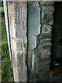
Worn grooves, porch of Cartmel Fell Church
Grooves worn in the stonework on both sides of the porch are reputed to be where bowmen of the parish sharpened their arrows during archery practice.
Image: © Karl and Ali
Taken: 25 Jan 2017
0.25 miles
8

Cartmel Fell Church
The church at Cartmel Fell hidden amongst the woodland.
Image: © George Hopkins
Taken: 27 Aug 2010
0.25 miles