
IMAGES TAKEN NEAR TO
Station Square, GRANGE-OVER-SANDS, LA11 6EH
Introduction
This page details the photographs taken nearby to Station Square, LA11 6EH by members of the Geograph project.
The Geograph project started in 2005 with the aim of publishing, organising and preserving representative images for every square kilometre of Great Britain, Ireland and the Isle of Man.

There are currently over 7.5m images from over14,400 individuals and you can help contribute to the project by visiting https://www.geograph.org.uk
Image Map
Images are licensed for reuse under creativecommons.org/licenses/by-sa/2.0
Notes
- Clicking on the map will re-center to the selected point.
- The higher the marker number, the further away the image location is from the centre of the postcode.
Image Listing (268 Images Found)
Images are licensed for reuse under creativecommons.org/licenses/by-sa/2.0
Image
Details
Distance
1

Lindale Road, Grange over Sands
View in the direction of Main Street from a point outside the Railway Station.
Image: © Brian Clift
Taken: 16 Apr 2010
0.01 miles

3

Cumbria Coastal Way
Information notice near the railway station in Grange-Over-Sands
Image: © Eirian Evans
Taken: 10 May 2021
0.03 miles
4

Riggs Close, Grange over Sands
View from Lindale Road also showing the Grange Hotel.
Image: © Brian Clift
Taken: 16 Apr 2010
0.03 miles
5
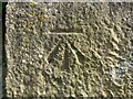
Benchmark, Grange-over-Sands Railway Station
Detail of the Ordnance Survey cut benchmark on the north face of the northeast corner of Grange-over-Sands railway station. The benchmark marks a height of 9.6481m above mean sea level (Ordnance Datum Newlyn) last verified in 1971 (location photograph Image).
Image: © Adrian Taylor
Taken: 3 May 2023
0.03 miles
6

The train now arriving ...
... at Grange Over Sands
Image: © Peter Turner
Taken: 5 Feb 2013
0.03 miles
7

Train leaving Grange-over-Sands - 1993
Diesel locomotive 31438 pulls out of Grange-over-Sands station with the 09.30 passenger service from Barrow to Preston.
Image: © The Carlisle Kid
Taken: 12 Jun 1993
0.03 miles
8

Ordnance Survey Cut Mark
This OS cut mark can be found on the Railway Station. It marks a point 9.648m above mean sea level.
Image: © Adrian Dust
Taken: 22 Feb 2022
0.03 miles
9

Railway towards Arnside
From Grange-over-Sands Railway Station.
Image: © JThomas
Taken: 5 Jul 2021
0.03 miles
10
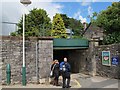
Grange-over-Sands: path under the railway
This pedestrian underpass beneath the railway line is the only access from the town centre to the westbound platform of the station, and also gives access to the promenade.
Image: © Stephen Craven
Taken: 2 Jul 2016
0.04 miles