
IMAGES TAKEN NEAR TO
Grange Fell Road, GRANGE-OVER-SANDS, LA11 6AS
Introduction
This page details the photographs taken nearby to Grange Fell Road, LA11 6AS by members of the Geograph project.
The Geograph project started in 2005 with the aim of publishing, organising and preserving representative images for every square kilometre of Great Britain, Ireland and the Isle of Man.

There are currently over 7.5m images from over14,400 individuals and you can help contribute to the project by visiting https://www.geograph.org.uk
Image Map
Images are licensed for reuse under creativecommons.org/licenses/by-sa/2.0
Notes
- Clicking on the map will re-center to the selected point.
- The higher the marker number, the further away the image location is from the centre of the postcode.
Image Listing (250 Images Found)
Images are licensed for reuse under creativecommons.org/licenses/by-sa/2.0
Image
Details
Distance
1

Hardcragg Hall
This Manor House was built in 1563 and is believed to be the oldest house in Grange-over-Sands. The property is now used as self catering holiday accommodation for larger groups.
More history on associated website http://www.hardcragghall.co.uk and photos on http://www.lake-districtselfcatering.co.uk.
Image: © Tony West
Taken: 11 Jun 2010
0.02 miles
2
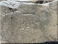
Benchmark, Grange Fell Road
Detail of an Ordnance Survey cut benchmark on a stone at the bottom of the south east corner of the garden wall of 10 Grange Fell Road. The benchmark marks a height of 50.495m above Ordnance Datum Newlyn last verified in 1972.
Image: © Adrian Taylor
Taken: 14 May 2022
0.02 miles
3
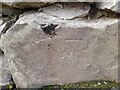
Ordnance Survey Cut Mark
This OS cut mark can be found at the entrance of High Gable, Grange Fell Road. It marks a point 50.495m above mean sea level.
Image: © Adrian Dust
Taken: 22 Feb 2022
0.03 miles
4
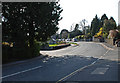
Grange Fell Road, Grange over Sands
Near its junction with Hardcragg Way.
Image: © Brian Clift
Taken: 16 Apr 2010
0.06 miles
5

Grange over Sands Methodist Church: mid-February 2015
Image: © Basher Eyre
Taken: 16 Feb 2015
0.08 miles
6

Ordnance Survey Cut Mark
This OS cut mark can be found on the wall north side of Grange Fell Road. It marks a point 30.543m above mean sea level.
Image: © Adrian Dust
Taken: 22 Feb 2022
0.08 miles
7
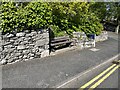
Seat, Grange Fell Road
Grange Fell Road climbs steeply from Grange town centre and this seat is provided opposite the end of Fernleigh Road to offer an opportunity for pedestrians to have a rest.
There is an Ordnance Survey cut benchmark on the bottom of the wall corner to the right of the seat (photograph Image).
Image: © Adrian Taylor
Taken: 14 May 2022
0.08 miles
8
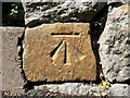
Benchmark, Grange Fell Road opposite Fernleigh Road
Detail of an Ordnance Survey cut benchmark on Grange Fell Road opposite Fernleigh Road.
The benchmark marks a height of 30.543m above Ordnance Datum Newlyn last levelled in 1972 (location photograph Image).
Image: © Adrian Taylor
Taken: 14 May 2022
0.08 miles
10
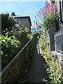
Footpath between Kents Bank Road and Fernleigh Road
The two roads are parallel, but like many other parallel roads in grange-over-Sands, they are on different contours.
Image: © Christine Johnstone
Taken: 6 Jun 2021
0.08 miles