
IMAGES TAKEN NEAR TO
Stone Terrace, GRANGE-OVER-SANDS, LA11 6AJ
Introduction
This page details the photographs taken nearby to Stone Terrace, LA11 6AJ by members of the Geograph project.
The Geograph project started in 2005 with the aim of publishing, organising and preserving representative images for every square kilometre of Great Britain, Ireland and the Isle of Man.

There are currently over 7.5m images from over14,400 individuals and you can help contribute to the project by visiting https://www.geograph.org.uk
Image Map
Images are licensed for reuse under creativecommons.org/licenses/by-sa/2.0
Notes
- Clicking on the map will re-center to the selected point.
- The higher the marker number, the further away the image location is from the centre of the postcode.
Image Listing (33 Images Found)
Images are licensed for reuse under creativecommons.org/licenses/by-sa/2.0
Image
Details
Distance
1

Ordnance Survey Cut Mark
This OS cut mark can be found on the north side of Grange Fell Road. It marks a point 80.606m above mean sea level.
Image: © Adrian Dust
Taken: 22 Feb 2022
0.05 miles
2
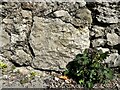
Benchmark, Milton Terrace, Grange Fell Road
Detail of the weathered Ordnance Survey cut benchmark on Grange Fell Road adjacent to Milton Terrace. The benchmark marks a height of 80.6061m above mean sea level (Ordnance Datum Newlyn) last verified in 1972 (location photograph Image).
Image: © Adrian Taylor
Taken: 1 Apr 2022
0.05 miles
3
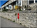
Postbox, Grange Fell Road
This postbox is on Grange Fell Road adjacent to Milton Terrace.
There is a weathered Ordnance Survey cut benchmark on one of the bottom stones in the wall below the postbox (photograph Image).
Image: © Adrian Taylor
Taken: 1 Apr 2022
0.05 miles
4

Former post office, Grange Fell Road
Now a house called 'The Old Post Office'.
Image: © Christine Johnstone
Taken: 9 Jun 2021
0.05 miles
5
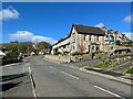
Grange Fell Road
Grange Fell Road at the junction of Fell Drive and Ashmount Road.
There is an Ordnance Survey cut benchmark on the wall under the red postbox on the far side of the crossroads (location photograph Image, detail photograph Image).
Image: © Adrian Taylor
Taken: 1 Apr 2022
0.05 miles
6

Unusual stone wall on Ashmount Road
Composed of massive slabs of water-worn limestone set vertically.
Image: © Oliver Dixon
Taken: 21 Apr 2024
0.07 miles
7
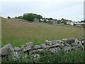
Urban fringe, Grange-over-Sands
Spring Bank Farm's barn was mapped here as early as 1847, but the houses only crept up the hill in the mid-1900s.
Image: © Christine Johnstone
Taken: 9 Jun 2021
0.10 miles
8

New home on Grange Fell
Marigold is one of two new homes at the end of The Crescent.
Image: © David M Clark
Taken: 20 Jul 2025
0.11 miles
9

Marigold on The Crescent
One of two new homes on Grange Fell.
Image: © David M Clark
Taken: 17 May 2026
0.11 miles
10

Ordnance Survey Cut Mark
This OS cut mark can be found on the junction of Fell Drive & Fell Close. It marks a point 70.078m above mean sea level.
Image: © Adrian Dust
Taken: 22 Feb 2022
0.12 miles