IMAGES TAKEN NEAR TO
Gwendoline Street, LIVERPOOL, L8 8EZ
Introduction
This page details the photographs taken nearby to Gwendoline Street, L8 8EZ by members of the Geograph project.
The Geograph project started in 2005 with the aim of publishing, organising and preserving representative images for every square kilometre of Great Britain, Ireland and the Isle of Man.

There are currently over 7.5m images from over14,400 individuals and you can help contribute to the project by visiting https://www.geograph.org.uk
Image Map (Loading...)


Getting Data...Please wait
Leaflet Map data © OpenStreetMap
Images are licensed for reuse under creativecommons.org/licenses/by-sa/2.0
Notes
- Clicking on the map will re-center to the selected point.
- The higher the marker number, the further away the image location is from the centre of the postcode.
Image Listing (41 Images Found)
Images are licensed for reuse under creativecommons.org/licenses/by-sa/2.0
Image
Details
Distance
1
Liverpool 8 contrasts (2)
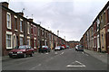
Elaine Street is the next street north from Merlin Street, and is a step down the ladder, the houses opening straight out onto the street. The detailing above and around the windows shows some effort was made to enhance their appearance.
Image: © David Long
Taken: 30 Mar 2006
0.07 miles
2
Madelaine Street, Princes Park regeneration zone
Looking north west along Madelaine Street. This entire area is changing as the 19th century terraced housing is swept away and replaced with more modern homes. Immediately on the right the old houses facing North Hill Street have gone, whilst on the right of this street the bay-windowed houses remain. However, on the left of the street the terrace has been replaced with modern housing. To the right of the trees the tower of the Anglican cathedral can be seen in the distance.
Image: © John S Turner
Taken: 6 Jan 2011
0.10 miles
3
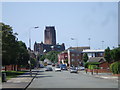
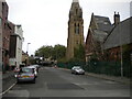
Looking down Windsor St, Liverpool
The Anglican Cathedral is prominent in the distance
Image: © John Lord
Taken: 16 Jun 2010
0.12 miles
4
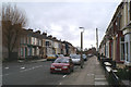
Liverpool 8 contrasts (1)
The houses on the main routes through Liverpool 8, like Princes Drive and Upper Parliament Street, had large, double-fronted terraces of houses. Once in the side-streets the contrasts began. Merlin Street's terraced houses, with their bay windows and tiny front gardens, were a couple of steps up the ladder.
Image: © David Long
Taken: 30 Mar 2006
0.13 miles
5
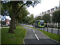
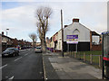
Cycle path alongside Princes Road, Princes Park
Built on part of the central reservation between Princes Road (right) and Princes Avenue (left). There is also a footpath along the central reservation, just visible on the left.
Image: © Richard Vince
Taken: 16 Sep 2020
0.15 miles
6
Princes Road and a bench mark
Looking along Princes Road in front of #92 and #94. The gatepost on the left has a bench mark Image
Image: © John S Turner
Taken: 6 Jan 2011
0.15 miles
7
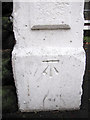
Bench mark in Princes Road
This cut bench mark is on a gatepost between #92 and #94 Princes Road. The area was developed in the second half of the 19th century and the mark is recorded from the 1891-1893 O.S. map onwards. See also Image
Image: © John S Turner
Taken: 6 Jan 2011
0.15 miles
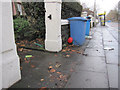
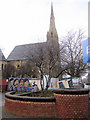
9
Upper Hill Street, Toxteth
Looking towards Princes Road from Gibson Road, with the remains of the Welsh Presbyterian Church visible ahead on the right.
Image: © Richard Vince
Taken: 16 Sep 2020
0.16 miles
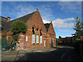
10
Beatles mural in Princes Road
The hoardings surrounding the derelict Calvinistic chapel have been enhanced with the addition of a Beatles mural. Chapel was built to accommodate 1,250 people. Princes Road is on the right.
Image: © John S Turner
Taken: 6 Jan 2011
0.16 miles