IMAGES TAKEN NEAR TO
Loudon Grove, LIVERPOOL, L8 8AT
Introduction
This page details the photographs taken nearby to Loudon Grove, L8 8AT by members of the Geograph project.
The Geograph project started in 2005 with the aim of publishing, organising and preserving representative images for every square kilometre of Great Britain, Ireland and the Isle of Man.

There are currently over 7.5m images from over14,400 individuals and you can help contribute to the project by visiting https://www.geograph.org.uk
Image Map (Loading...)


Getting Data...Please wait
Leaflet Map data © OpenStreetMap
Images are licensed for reuse under creativecommons.org/licenses/by-sa/2.0
Notes
- Clicking on the map will re-center to the selected point.
- The higher the marker number, the further away the image location is from the centre of the postcode.
Image Listing (73 Images Found)
Images are licensed for reuse under creativecommons.org/licenses/by-sa/2.0
Image
Details
Distance
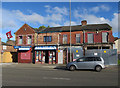
1
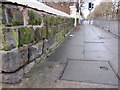
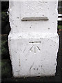
Princes Road and a bench mark
Looking along Princes Road from its junction with North Hill Street. On the left there is a bench mark on the corner of the stone wall Image
Image: © John S Turner
Taken: 6 Jan 2011
0.07 miles
2
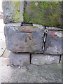
Cut bench mark on the corner of Princes Road and North Hill Street
This cut bench mark faces Princes Road at its junction with North Hill Street. The area was developed in the second half of the 19th century and the mark is first shown on the 1891-1893 O.S. map. See also Image
Image: © John S Turner
Taken: 6 Jan 2011
0.07 miles
3
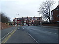
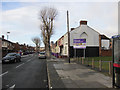
Upper Warwick Street looking towards Princes Road junction.
Image: © Colin Pyle
Taken: 13 Feb 2010
0.07 miles
5
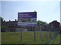
Regeneration zone, Liverpool
On High Park St, between Kelvin Grove and Wynnstay St
Image: © John Lord
Taken: 16 Jun 2010
0.08 miles
7
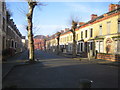
Madelaine Street, Princes Park regeneration zone
Looking north west along Madelaine Street. This entire area is changing as the 19th century terraced housing is swept away and replaced with more modern homes. Immediately on the right the old houses facing North Hill Street have gone, whilst on the right of this street the bay-windowed houses remain. However, on the left of the street the terrace has been replaced with modern housing. To the right of the trees the tower of the Anglican cathedral can be seen in the distance.
Image: © John S Turner
Taken: 6 Jan 2011
0.10 miles
9
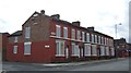
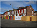
Liverpool: Ducie Street, Princes Park, L8
A tree-lined cul-de-sac street, devoid of parked cars bar one, containing about 20 large Mid-Victorian terraced houses on each side. How much would these houses be worth in London? £500,000 at present-day prices?
But this is Liverpool. The houses are all empty, all the doors and windows are bricked up, and some of the roofs are missing. The whole street is under the threat of demolition by the local council.
Image shows a house in this street in detail.
Image: © Nigel Cox
Taken: 18 Feb 2007
0.11 miles
10
Bench mark in Princes Road
This cut bench mark is on a gatepost between #92 and #94 Princes Road. The area was developed in the second half of the 19th century and the mark is recorded from the 1891-1893 O.S. map onwards. See also Image
Image: © John S Turner
Taken: 6 Jan 2011
0.11 miles