IMAGES TAKEN NEAR TO
Voelas Street, LIVERPOOL, L8 3AA
Introduction
This page details the photographs taken nearby to Voelas Street, L8 3AA by members of the Geograph project.
The Geograph project started in 2005 with the aim of publishing, organising and preserving representative images for every square kilometre of Great Britain, Ireland and the Isle of Man.

There are currently over 7.5m images from over14,400 individuals and you can help contribute to the project by visiting https://www.geograph.org.uk
Image Map (Loading...)


Getting Data...Please wait
Leaflet Map data © OpenStreetMap
Images are licensed for reuse under creativecommons.org/licenses/by-sa/2.0
Notes
- Clicking on the map will re-center to the selected point.
- The higher the marker number, the further away the image location is from the centre of the postcode.
Image Listing (85 Images Found)
Images are licensed for reuse under creativecommons.org/licenses/by-sa/2.0
Image
Details
Distance
1
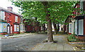
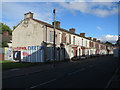
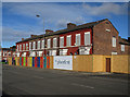
Voelas Street, Liverpool
One of the so-called Welsh Streets. And one of numerous streets of Victorian terraced houses condemned to, or at least slated for, demolition under the misguided 'Pathfinder' initiative which ran from 2002 to 2011. Liverpool seems to have been more afflicted than anywhere else. These houses have subsequently been restored (the mature trees were sacrificed in the process), and new houses built on the south end of the street which had already been cleared (Image]).
Image: © Stephen Richards
Taken: 15 Jun 2016
0.02 miles
2
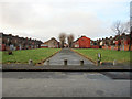
Voelas Street, Toxteth
Looking across South Street and north-west along Voelas Street, one of the Welsh Streets. Part of the street was demolished by the 1980s and now the rest of it is due for demolition in phase 1 of the Princes Park regeneration zone project.
Image: © John S Turner
Taken: 6 Jan 2011
0.03 miles
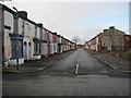
3
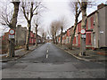
Wynnstay Street, Toxteth
Looking north-west along Wynnstay Street, one of the Welsh Streets, from its junction with South Street, and the tower of the Anglican cathedral can be seen beyond the end of the street. The street signs state that this is a 'play street', though with the houses now boarded up there are no children to play here. Wynnstay Street is due for demolition in phase 1 of the Princes Park regeneration zone project.
Image: © John S Turner
Taken: 6 Jan 2011
0.03 miles
4
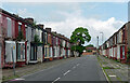
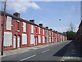
Rhiwlas Street, Liverpool
One of the so-called Welsh Streets. And one of numerous streets of Victorian terraced houses condemned to, or at least slated for, demolition under the misguided 'Pathfinder' initiative which ran from 2002 to 2011. Liverpool seems to have been more afflicted than anywhere else. These houses have subsequently been restored (the mature tree was sacrificed in the process), and new houses built on the south-east section of the street which had already been cleared.
Image: © Stephen Richards
Taken: 15 Jun 2016
0.04 miles
5
Rhiwlas Street
One of the boarded up Welsh Streets
Image: © Hugh Venables
Taken: 5 Sep 2016
0.04 miles
6
Rhiwlas St, Liverpool, awaiting regeneration
Image: © John Lord
Taken: 16 Jun 2010
0.04 miles
7
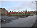
Junction of Rhiwlas Street and South Street
Looking north across the junction of Rhiwlas Street and South Street. The cleared ground behind Rhiwlas Street was once Voelas Street, part of which still stands. The east side (right) of Rhwlas Street is due for demolition in phase 1 of the Princes Park regeneration zone project, whilst the west side (left) is part of phase 2.
Image: © John S Turner
Taken: 6 Jan 2011
0.04 miles
8
Rhiwlas Street, Toxteth
Looking north-west along Rhiwlas Street, one of the Welsh Streets. The east side (right) of Rhiwlas Street is due for demolition in phase 1 of the Princes Park regeneration zone project, whilst the west side (left) is part of phase 2. Some of the houses on the east side of the road have already gone and had been demolished by the time of the 1989 O.S map.
Image: © John S Turner
Taken: 6 Jan 2011
0.04 miles
10
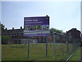
Regeneration zone, Liverpool
On High Park St, between Kelvin Grove and Wynnstay St
Image: © John Lord
Taken: 16 Jun 2010
0.05 miles