IMAGES TAKEN NEAR TO
L69 8AR
Introduction
This page details the photographs taken nearby to L69 8AR by members of the Geograph project.
The Geograph project started in 2005 with the aim of publishing, organising and preserving representative images for every square kilometre of Great Britain, Ireland and the Isle of Man.

There are currently over 7.5m images from over14,400 individuals and you can help contribute to the project by visiting https://www.geograph.org.uk
Image Map
Images are licensed for reuse under creativecommons.org/licenses/by-sa/2.0
Notes
- Clicking on the map will re-center to the selected point.
- The higher the marker number, the further away the image location is from the centre of the postcode.
Image Listing (38 Images Found)
Images are licensed for reuse under creativecommons.org/licenses/by-sa/2.0
Image
Details
Distance
1
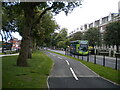
Cycle path alongside Princes Road, Princes Park
Built on part of the central reservation between Princes Road (right) and Princes Avenue (left). There is also a footpath along the central reservation, just visible on the left.
Image: © Richard Vince
Taken: 16 Sep 2020
0.08 miles
2
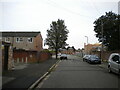
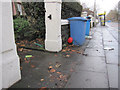
Rosebery Street, Toxteth
Off Princes Avenue. Al Rahma Masjid is visible ahead on the right.
Image: © Richard Vince
Taken: 16 Sep 2020
0.08 miles
3
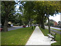
Central reservation footpath, Toxteth
Between Princes Avenue (left) and Princes Road (right), with a cycle path between the footpath and the latter.
Image: © Richard Vince
Taken: 16 Sep 2020
0.09 miles
4
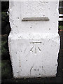
Bench mark in Princes Road
This cut bench mark is on a gatepost between #92 and #94 Princes Road. The area was developed in the second half of the 19th century and the mark is recorded from the 1891-1893 O.S. map onwards. See also Image
Image: © John S Turner
Taken: 6 Jan 2011
0.11 miles
5
Princes Road and a bench mark
Looking along Princes Road in front of #92 and #94. The gatepost on the left has a bench mark Image
Image: © John S Turner
Taken: 6 Jan 2011
0.11 miles
6
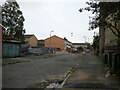
Northbrook Street, Toxteth
Off Princes Avenue.
Image: © Richard Vince
Taken: 16 Sep 2020
0.11 miles
7
Beatles mural in Princes Road
The hoardings surrounding the derelict Calvinistic chapel have been enhanced with the addition of a Beatles mural. Chapel was built to accommodate 1,250 people. Princes Road is on the right.
Image: © John S Turner
Taken: 6 Jan 2011
0.12 miles
8
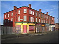
Liverpool: Granby Street, Princes Park, L8
Derelict shops and housing at the junction of Granby Street with Cawdor Street. This block is just north of Image, and is visible on the right side of that photograph. The yellow painted corner shop is / was No. 122 Granby Street.
Image: © Nigel Cox
Taken: 18 Feb 2007
0.12 miles
9
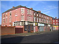
Liverpool: Granby Street, Princes Park, L8
Derelict shops and housing at the junction of Granby Street with Arundel Street.
Image: © Nigel Cox
Taken: 18 Feb 2007
0.12 miles