IMAGES TAKEN NEAR TO
L66 2WL
Introduction
This page details the photographs taken nearby to L66 2WL by members of the Geograph project.
The Geograph project started in 2005 with the aim of publishing, organising and preserving representative images for every square kilometre of Great Britain, Ireland and the Isle of Man.

There are currently over 7.5m images from over14,400 individuals and you can help contribute to the project by visiting https://www.geograph.org.uk
Image Map
Images are licensed for reuse under creativecommons.org/licenses/by-sa/2.0
Notes
- Clicking on the map will re-center to the selected point.
- The higher the marker number, the further away the image location is from the centre of the postcode.
Image Listing (11 Images Found)
Images are licensed for reuse under creativecommons.org/licenses/by-sa/2.0
Image
Details
Distance
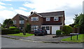
1
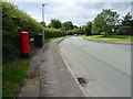
Sycamore Drive, Ellesmere Port
Showing position of Postbox No. CH66 496.
See Image] for postbox.
Image: © JThomas
Taken: 15 Jun 2019
0.10 miles
2
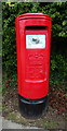
Elizabeth II postbox on Sycamore Drive, Ellesmere Port
Postbox No. CH66 496.
See Image] for context.
Image: © JThomas
Taken: 15 Jun 2019
0.11 miles
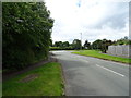
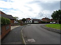
6
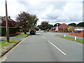
Willowdale Way, Ellesmere Port
In the suburbs.
Image: © JThomas
Taken: 15 Jun 2019
0.18 miles
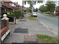
8
Sycamore Drive, Ellesmere Port
In the suburbs.
Image: © JThomas
Taken: 15 Jun 2019
0.21 miles
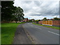
9
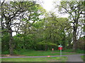
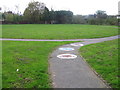
Woodland, Willowdale Way
Small strip of woodland facing Holm Oak Way.
Image: © Sue Adair
Taken: 7 May 2012
0.22 miles