IMAGES TAKEN NEAR TO
Belmont View, LIVERPOOL, L6 5ED
Introduction
This page details the photographs taken nearby to Belmont View, L6 5ED by members of the Geograph project.
The Geograph project started in 2005 with the aim of publishing, organising and preserving representative images for every square kilometre of Great Britain, Ireland and the Isle of Man.

There are currently over 7.5m images from over14,400 individuals and you can help contribute to the project by visiting https://www.geograph.org.uk
Image Map
Images are licensed for reuse under creativecommons.org/licenses/by-sa/2.0
Notes
- Clicking on the map will re-center to the selected point.
- The higher the marker number, the further away the image location is from the centre of the postcode.
Image Listing (4 Images Found)
Images are licensed for reuse under creativecommons.org/licenses/by-sa/2.0
Image
Details
Distance
1
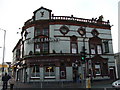
The Belmont, Belmont Road, Anfield
A classic Liverpool pub
Image: © S Parish
Taken: 10 Nov 2009
0.02 miles
2
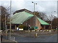
St Margaret's church, Anfield
A modern (1960s) place of worship with a copper roof, on a busy road junction.
Image: © Stephen Craven
Taken: 4 Nov 2017
0.04 miles
3
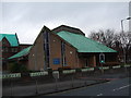
St Margaret, Anfield
Consecrated 27/11/1965, architect Bruxby and Evans (previous church of 1873 burned down in 1961)
Image: © S Parish
Taken: 10 Nov 2009
0.07 miles
4
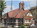
Rockfield House, Rocky Lane
Rockfield House on Rocky Lane is a community based residential home for people with a learning disabilities. It was previously St Margaret's C of E Primary School.
Image: © Sue Adair
Taken: 4 Jul 2011
0.08 miles