IMAGES TAKEN NEAR TO
L60 7SQ
Introduction
This page details the photographs taken nearby to L60 7SQ by members of the Geograph project.
The Geograph project started in 2005 with the aim of publishing, organising and preserving representative images for every square kilometre of Great Britain, Ireland and the Isle of Man.

There are currently over 7.5m images from over14,400 individuals and you can help contribute to the project by visiting https://www.geograph.org.uk
Image Map
Images are licensed for reuse under creativecommons.org/licenses/by-sa/2.0
Notes
- Clicking on the map will re-center to the selected point.
- The higher the marker number, the further away the image location is from the centre of the postcode.
Image Listing (34 Images Found)
Images are licensed for reuse under creativecommons.org/licenses/by-sa/2.0
Image
Details
Distance
2
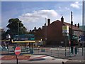
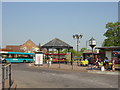
Heswall Bus Station
There has been a bus station on this site since 1924 and until 1988 there was also a Crosville depot. The facility is smaller in size than it was in its heyday and a pub - the Johnny Pye - now occupies part of the old depot site. Nevertheless, there are still services to the main Wirral destinations as well as to Liverpool operated by a variety of companies including Arriva and Stagecoach.
Image: © Stephen McKay
Taken: 5 Apr 2018
0.01 miles
3
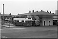
Heswall Bus Station ? 1971
Built by Crosville Motor Services who were the main bus operator in Wirral outside Birkenhead and Wallasey. However as part of an agreement in the inter-war period between Birkenhead Corporation and Crosville, the former was able to operate buses well outside the borough boundaries. Nearer the camera is Merseyside PTE 188, a Leyland Atlantean with Northern Counties bodywork ordered by Birkenhead Corporation, but delivered in 1971 to the PTE which had taken over all the local municipal operators in 1970.
This is one of a series of views featuring buses in the 60s, 70s, and 80s. http://www.geograph.org.uk/search.php?i=137652761
Image: © Alan Murray-Rust
Taken: 6 Feb 1971
0.01 miles
4
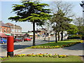
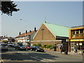
Telegraph Road, Heswall
Roadside flowerbeds near the library on Telegraph Road (A540), Heswall.
Image: © Sue Adair
Taken: 10 May 2006
0.02 miles
6
Telegraph Road, Heswall
Taken outside the library where some spring sunshine (at last!) is brightening up the scene and the bedding plants by the path.
Image: © Stephen McKay
Taken: 5 Apr 2018
0.04 miles
7
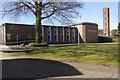
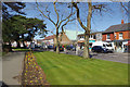
Heswall Hall
Heswall Hall is owned by Wirral Council but has been managed by Heswall Hall Community Trust since 2011. It is a venue for a wide variety of functions including concerts, wedding receptions, business meetings and community activities. The adjacent tower belongs to the fire station.
Image: © Stephen McKay
Taken: 5 Apr 2018
0.06 miles
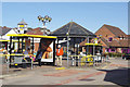
8
Heswall Bus Station
Heswall Bus Station on Telegraph Road.
Image: © Sue Adair
Taken: 10 May 2006
0.06 miles
9
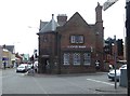
Lloyd's Bank, Heswall
Built for the bank in 1907 by George Hastwell Grayson. It is situated at the junction of Telegraph Road and The Mount.
Image: © Eirian Evans
Taken: 17 May 2016
0.07 miles
10
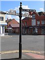
Old Direction Sign - Signpost by the A540, Telegraph Road, Heswall
Pawn finial - 3 arms; Cheshire CCC octagonal (Smith) by the A540, in parish of Heswall (Wirral District), junction of Telegraph Road and The Mount.
Column inscription reads:- : W H SMITH & Co / WHITCHURCH SALOP :
Plus 'CCC' shield.
To be surveyed
Milestone Society National ID: CH_SJ2681.
Image: © John S Turner
Taken: 7 Sep 2016
0.08 miles