IMAGES TAKEN NEAR TO
Snowdon Lane, LIVERPOOL, L5 9RB
Introduction
This page details the photographs taken nearby to Snowdon Lane, L5 9RB by members of the Geograph project.
The Geograph project started in 2005 with the aim of publishing, organising and preserving representative images for every square kilometre of Great Britain, Ireland and the Isle of Man.

There are currently over 7.5m images from over14,400 individuals and you can help contribute to the project by visiting https://www.geograph.org.uk
Image Map (Loading...)


Getting Data...Please wait
Leaflet Map data © OpenStreetMap
Images are licensed for reuse under creativecommons.org/licenses/by-sa/2.0
Notes
- Clicking on the map will re-center to the selected point.
- The higher the marker number, the further away the image location is from the centre of the postcode.
Image Listing (84 Images Found)
Images are licensed for reuse under creativecommons.org/licenses/by-sa/2.0
Image
Details
Distance
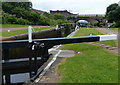
1
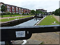
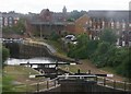
Stanley Top Lock No 1 on the Leeds and Liverpool Canal
The houses on the left are on Lockfields View, in the Vauxhall area of Liverpool.
Image: © Mat Fascione
Taken: 26 Jun 2016
0.08 miles
2
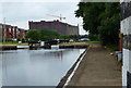
Stanley Top Lock No 1 on the Leeds and Liverpool Canal
Looking west towards the huge grade II listed Stanley Dock Tobacco Warehouse, the world's largest brick warehouse.
Image: © Mat Fascione
Taken: 26 Jun 2016
0.09 miles
3
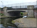
Barmouth Way Bridge C
Crossing the Leeds and Liverpool Canal in the Vauxhall area of Liverpool.
Image: © Mat Fascione
Taken: 26 Jun 2016
0.09 miles
4
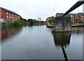
Pipebridge at Stanley Dock Cut Junction
On the Leeds and Liverpool Canal in the Vauxhall area of Liverpool.
Image: © Mat Fascione
Taken: 26 Jun 2016
0.09 miles
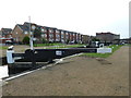
5
Stanley Lock No 2 on the Leeds and Liverpool Canal
Image: © Mat Fascione
Taken: 26 Jun 2016
0.10 miles
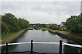
7
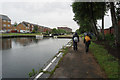
Leeds & Liverpool Canal
Towards Vauxhall Bridge.
Image: © Ian S
Taken: 11 Jun 2019
0.10 miles
8
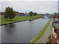
Leeds-Liverpool Canal
Leeds-Liverpool canal from Boundary Road bridge (dated 1848) showing the cast iron Athol Street Bridge. With the growth of Liverpool in the late 18th and early 19th century, the development of Vauxhall as an industrial area was inevitable with the building of the canal, construction of new docks and the coming of the railways, the low lying strip of land close to the river was the natural location for industry and its work-force. By the late 1840s Vauxhall was already industrialised - its character in manufacturing consisting of iron foundries, soap, alkali, chemicals and other manufactories drawing a dense population of labouring people, supported to a considerable extent by abundant local employment.
Image: © Sue Adair
Taken: 29 Oct 2005
0.10 miles
9
Leeds to Liverpool Canal at Vauxhall, Liverpool
Image: © Mike Pennington
Taken: 10 Jul 2010
0.10 miles
10
Leeds & Liverpool Canal
At Liverpool Canal Link.
Image: © Ian S
Taken: 11 Jun 2019
0.10 miles