IMAGES TAKEN NEAR TO
Walton Hall Avenue, LIVERPOOL, L4 9XP
Introduction
This page details the photographs taken nearby to Walton Hall Avenue, L4 9XP by members of the Geograph project.
The Geograph project started in 2005 with the aim of publishing, organising and preserving representative images for every square kilometre of Great Britain, Ireland and the Isle of Man.

There are currently over 7.5m images from over14,400 individuals and you can help contribute to the project by visiting https://www.geograph.org.uk
Image Map
Images are licensed for reuse under creativecommons.org/licenses/by-sa/2.0
Notes
- Clicking on the map will re-center to the selected point.
- The higher the marker number, the further away the image location is from the centre of the postcode.
Image Listing (10 Images Found)
Images are licensed for reuse under creativecommons.org/licenses/by-sa/2.0
Image
Details
Distance

2
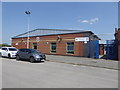
Liverpool Soccer Centre
HQ at Walton Hall Sports Centre.
Image: © Eirian Evans
Taken: 12 May 2016
0.02 miles
3
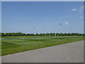
Football pitch at Walton Hall Sports Centre
Pristine pitch being mowed by hand
Image: © Eirian Evans
Taken: 12 May 2016
0.06 miles
4
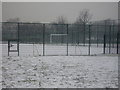
Walton Hall Park Astro Football Pitch
Taken in early February 2007 from the car park which is next to the sports centre.
Image: © andy miller
Taken: Unknown
0.09 miles
5
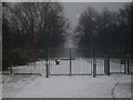
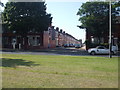
Walton Hall Park
Walton Hall Park (snow has fallen) to the left is the sports centre, the East Lancs Road is to the right.
Image: © andy miller
Taken: Unknown
0.09 miles
6
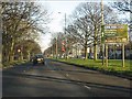
Manchester this way
Sign on Walton Hall Avenue, just east of Woolhope Avenue. Once the start of the brave new world of the A580, from 1934 the ultra-modern fast route between Liverpool and Manchester until superseded by the M62 exactly forty years later.
Image: © Peter Whatley
Taken: 17 Jan 2012
0.10 miles
7
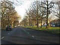
The broad highway east
Typical of the suburban dual carriageways constructed in Liverpool's outer suburbs in the 1920s/30s, Walton Hall Avenue retains its broad main carriageway and wide, tree-lined central reservation. Entirely suitable for its sometime role as the main highway from Liverpool's docks toward the rest of Lancashire. A classic of town planning.
Image: © Peter Whatley
Taken: 17 Jan 2012
0.22 miles
8
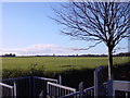
Walton Hall Park
Looking across the football pitches towards Walton Church from the gate of Walton Hall Park. The sports centre is the building to the left of the photo. The 130-acre park to the public in 1934 by King George V, on the same day as he opened the Mersey Tunnel.
Image: © Sue Adair
Taken: 14 Jan 2006
0.24 miles
10
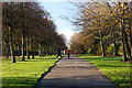
Footpath beside Walton Hall Avenue, Liverpool
Image: © Mike Pennington
Taken: 21 Nov 2015
0.25 miles