IMAGES TAKEN NEAR TO
Salt Pit Lane, ORMSKIRK, L40 2QX
Introduction
This page details the photographs taken nearby to Salt Pit Lane, L40 2QX by members of the Geograph project.
The Geograph project started in 2005 with the aim of publishing, organising and preserving representative images for every square kilometre of Great Britain, Ireland and the Isle of Man.

There are currently over 7.5m images from over14,400 individuals and you can help contribute to the project by visiting https://www.geograph.org.uk
Image Map
Images are licensed for reuse under creativecommons.org/licenses/by-sa/2.0
Notes
- Clicking on the map will re-center to the selected point.
- The higher the marker number, the further away the image location is from the centre of the postcode.
Image Listing (9 Images Found)
Images are licensed for reuse under creativecommons.org/licenses/by-sa/2.0
Image
Details
Distance
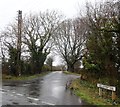
2

Waterlogged farm track
Looking west from Salt Pit Lane.
Image: © JThomas
Taken: 25 Oct 2014
0.10 miles

6
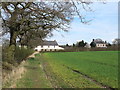
Footpath between Blue Stone Lane and Salt Pit Lane, Mawdesley
Image: © Gary Rogers
Taken: 13 Apr 2016
0.19 miles
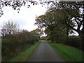
7
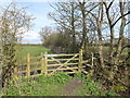
Footpath from Salt Pit Lane to Tannersmith Lane
Near Barrett's Farm
Image: © Gary Rogers
Taken: 13 Apr 2016
0.22 miles
8
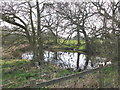
Pond near Barrett's Farm
On path between Salt Pit Lane and Tannersmith Lane
Image: © Gary Rogers
Taken: 13 Apr 2016
0.23 miles
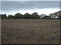
9

Natural England designated Wildlife Haven, Mawdesley
South of the footpath between Blue Stone Lane and Salt Pit Lane
Image: © Gary Rogers
Taken: 13 Apr 2016
0.25 miles