IMAGES TAKEN NEAR TO
London Road, LIVERPOOL, L3 9TA
Introduction
This page details the photographs taken nearby to London Road, L3 9TA by members of the Geograph project.
The Geograph project started in 2005 with the aim of publishing, organising and preserving representative images for every square kilometre of Great Britain, Ireland and the Isle of Man.

There are currently over 7.5m images from over14,400 individuals and you can help contribute to the project by visiting https://www.geograph.org.uk
Image Map
Images are licensed for reuse under creativecommons.org/licenses/by-sa/2.0
Notes
- Clicking on the map will re-center to the selected point.
- The higher the marker number, the further away the image location is from the centre of the postcode.
Image Listing (66 Images Found)
Images are licensed for reuse under creativecommons.org/licenses/by-sa/2.0
Image
Details
Distance
1
Junction of Moss Street and Prescot Street, Liverpool
On the right is the baroque-influenced Martins Bank, 1905. The gothic building opposite, between London Road and Moss Street, is the former Prince of Wales pub (closed in 1999), now converted into student accommodation behind the facade (thanks to Sue Adair for this information).
Image: © Derek Harper
Taken: 17 Jul 2006
0.02 miles
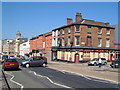
2

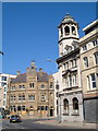
Junction of London Road, Moss Street and several others, Liverpool
Visible straight ahead, on the corner of Moss Street (left) and Prescot Street (right), is the former Bank of Liverpool. Towards the left is the former Prince of Wales public house; both buildings are grade-II listed. Adjoining the Prince of Wales public house, on the extreme left, is Albert Court (formerly Opal Court), a student accommodation building completed in 2006. It adjoins the Prince of Wales on its opposite side too, and incorporates part of the interior for its uses. Most of the original building, however, is disused and this is very much evident from outside. The fourth road is Daulby Street.
Image: © Oliver Mills
Taken: 18 Sep 2023
0.02 miles
3
Daulby Street, Liverpool
Showing the Spiritualist Church and the Roy Castle International Centre for Lung Cancer Research; junction with London Road in the background.
Image: © Derek Harper
Taken: 17 Jul 2006
0.02 miles
4

Former Bank of Liverpool, Prescot Street, Liverpool
Typical Edwardian Baroque bank building, though its octagonal tower is a cut above most. Pevsner picks out the contrast between its convex balconies and concave entablature. Built of Portland stone above a grey granite ground floor. By James F. Doyle, 1904. Grade II listed.
Later a Barclays Bank, I'm not sure it was occupied when the photo was taken.
Image: © Stephen Richards
Taken: 27 Jul 2011
0.03 miles
5
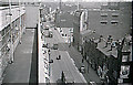
London Road, Liverpool, 1955
A 1955 view of London Road, looking East from the roof of "Co-operative House" one of the Liverpool Co-operative Society's city centre department stores. Although the building remains, the store has long since gone, as has the society and the trams.
Image: © Gordon Cragg
Taken: Unknown
0.04 miles
6
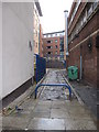
Old access lane off London Road
This old lane provides access to the rear of the buildings facing London Road. It still retains its surface of old granite setts.
Image: © John S Turner
Taken: 19 Dec 2009
0.05 miles
7
The Old Fort, Prescot Street, Liverpool
The north side of Prescot street, with The Old Fort pub on the corner of Moira Street; taken from in front of University Hospital.
Image: © Derek Harper
Taken: 17 Jul 2006
0.08 miles
8

The Old Fort public house, Liverpool
On Prescot Street.
Image: © JThomas
Taken: 28 Apr 2019
0.09 miles
9
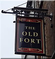
Sign for the Old Fort public house, Liverpool
Image: © JThomas
Taken: 28 Apr 2019
0.09 miles
10
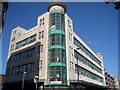
The Old Co-Operative Building, London Road
The old Co-Operative Building in London Road, once a busy department store and supermarket. This art deco building has now been turned into student accommodation.
Image: © Sue Adair
Taken: 20 Sep 2009
0.10 miles