IMAGES TAKEN NEAR TO
L38 9GB
Introduction
This page details the photographs taken nearby to L38 9GB by members of the Geograph project.
The Geograph project started in 2005 with the aim of publishing, organising and preserving representative images for every square kilometre of Great Britain, Ireland and the Isle of Man.

There are currently over 7.5m images from over14,400 individuals and you can help contribute to the project by visiting https://www.geograph.org.uk
Image Map
Images are licensed for reuse under creativecommons.org/licenses/by-sa/2.0
Notes
- Clicking on the map will re-center to the selected point.
- The higher the marker number, the further away the image location is from the centre of the postcode.
Image Listing (15 Images Found)
Images are licensed for reuse under creativecommons.org/licenses/by-sa/2.0
Image
Details
Distance
3
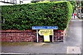
Garden open for charity
One of 5 gardens open in Hightown under the National Garden Scheme
Image: © Norman Caesar
Taken: 20 May 2018
0.11 miles
4
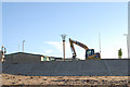
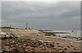
New sea defences at Hightown
Coastal engineering work currently in progress to update the crumbled sea defences and replace the old wooden sailing club hut at Hightown.
Image: © Gary Rogers
Taken: 15 Dec 2010
0.20 miles
5
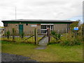
Blundellsands Sailing Club
The sailing times are limited to a period 2.5 hours either side of high tide.
Image: © John M
Taken: 17 Feb 2018
0.20 miles
6
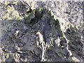
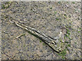
Ancient tree stump at Hightown
The remains trees and an ancient forest floor revealed in the sediment at Hightown at low tide.
Image: © Gary Rogers
Taken: 12 Jun 2010
0.20 miles
10
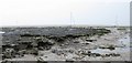
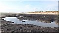
Ancient forest floor at Hightown
This peaty layer revealed by tidal processes contains the remains of a forest that covered the area around 4500 years ago. The peat layer is around 50cm thick and contains some remarkably well preserved tree and flora remains.
Image: © Gary Rogers
Taken: 20 Jul 2010
0.22 miles