IMAGES TAKEN NEAR TO
Cuper Crescent, LIVERPOOL, L36 3RP
Introduction
This page details the photographs taken nearby to Cuper Crescent, L36 3RP by members of the Geograph project.
The Geograph project started in 2005 with the aim of publishing, organising and preserving representative images for every square kilometre of Great Britain, Ireland and the Isle of Man.

There are currently over 7.5m images from over14,400 individuals and you can help contribute to the project by visiting https://www.geograph.org.uk
Image Map
Images are licensed for reuse under creativecommons.org/licenses/by-sa/2.0
Notes
- Clicking on the map will re-center to the selected point.
- The higher the marker number, the further away the image location is from the centre of the postcode.
Image Listing (7 Images Found)
Images are licensed for reuse under creativecommons.org/licenses/by-sa/2.0
Image
Details
Distance
1
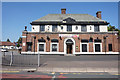
The Oak Tree Public House
On Liverpool Road, Huyton.
Image: © Ian S
Taken: 23 Jul 2019
0.09 miles
4
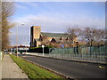
St Aloysius R.C.Church, Twig Lane, Huyton-with-Roby
Image: © John Lord
Taken: 27 Dec 2011
0.20 miles
5
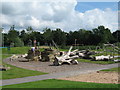
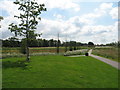
Alt Park Endmoor Road
Alt Park in Endmoor Road adjacent to the Huyton Resource Centre, once the worst rated park in the borough has recently received a facelift with the addition of a children's playground, natural playground and wildflower meadow. It hosted a family fun day in the summer holidays with fairground rides and attractions including a bouncy castle, rodeo bull, face painting and stalls.
Image: © Sue Adair
Taken: 8 Aug 2012
0.22 miles
6
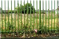
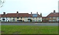
Demolished day nursery, Montgomery Road
Image: © Alex McGregor
Taken: 21 Oct 2014
0.23 miles
7
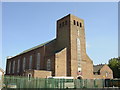
St Aloysius Church, Twig Lane, Huyton
St Aloysius church is located in Twig Lane Huyton. It has a popular social club and a primary school adjacent to the church.
Image: © Sue Adair
Taken: 2 Jun 2006
0.23 miles