IMAGES TAKEN NEAR TO
Brierley Close, BOOTLE, L30 7QH
Introduction
This page details the photographs taken nearby to Brierley Close, L30 7QH by members of the Geograph project.
The Geograph project started in 2005 with the aim of publishing, organising and preserving representative images for every square kilometre of Great Britain, Ireland and the Isle of Man.

There are currently over 7.5m images from over14,400 individuals and you can help contribute to the project by visiting https://www.geograph.org.uk
Image Map
Images are licensed for reuse under creativecommons.org/licenses/by-sa/2.0
Notes
- Clicking on the map will re-center to the selected point.
- The higher the marker number, the further away the image location is from the centre of the postcode.
Image Listing (15 Images Found)
Images are licensed for reuse under creativecommons.org/licenses/by-sa/2.0
Image
Details
Distance
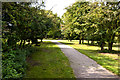
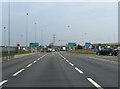
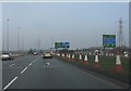
2
Road junction near the start of the motorway
Image: © Rob Purvis
Taken: 8 Aug 2016
0.10 miles
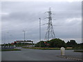
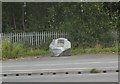
6
The new section, Switch Island
As part of a 2006 redesign, the northbound M57 now contiunues across half the original Switch Island roundabout to end at a T-junction. However, in a flash of brilliance, the new junction's design features two possible right turns, the first of which provides three lanes straight back onto the M57! You have to see it to believe it. See: http://www.cbrd.co.uk/badjunctions/57-58-59/ for more details.
Image: © Peter Whatley
Taken: 23 Mar 2012
0.14 miles
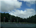
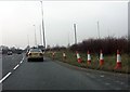
8
A59 at Switch Island
The northbound A59 is now free-flowing across half of Switch Island, with a further three lanes to the right for access to the M57, one of which also functions as an escape lane for traffic to Liverpool or Ormskirk which has taken the wrong right-turn at the end of that motorway. For more see: http://www.geograph.org.uk/photo/2884695 and http://www.cbrd.co.uk/badjunctions/57-58-59/ .
Image: © Peter Whatley
Taken: 23 Mar 2012
0.17 miles