IMAGES TAKEN NEAR TO
Hawthorne Avenue, LIVERPOOL, L26 9XB
Introduction
This page details the photographs taken nearby to Hawthorne Avenue, L26 9XB by members of the Geograph project.
The Geograph project started in 2005 with the aim of publishing, organising and preserving representative images for every square kilometre of Great Britain, Ireland and the Isle of Man.

There are currently over 7.5m images from over14,400 individuals and you can help contribute to the project by visiting https://www.geograph.org.uk
Image Map
Images are licensed for reuse under creativecommons.org/licenses/by-sa/2.0
Notes
- Clicking on the map will re-center to the selected point.
- The higher the marker number, the further away the image location is from the centre of the postcode.
Image Listing (10 Images Found)
Images are licensed for reuse under creativecommons.org/licenses/by-sa/2.0
Image
Details
Distance
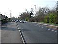
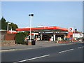
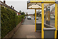
1
Higher Road Halewood
Looking East along the A562 at Halewood near the Jaguar factory, Total petrol station on the left in the distance
Image: © Sue Adair
Taken: 5 Oct 2005
0.06 miles
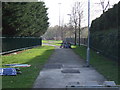
3
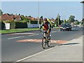
Slow - cyclist
Cycling along main out of town highway
Image: © Joan G
Taken: 6 Oct 2007
0.11 miles
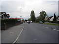
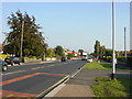
5
Halewood Police Station
At the junction of the A563, Higher Road, and Leather's Lane.
Image: © Eirian Evans
Taken: 31 May 2016
0.13 miles
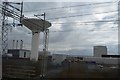
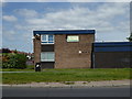
7
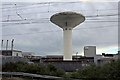
Jaguar building, Halewood
Viewed along the railway line, from Runcorn to Liverpool South Parkway.
Image: © El Pollock
Taken: 8 Jun 2014
0.20 miles