IMAGES TAKEN NEAR TO
Acresgate Court, LIVERPOOL, L25 4UF
Introduction
This page details the photographs taken nearby to Acresgate Court, L25 4UF by members of the Geograph project.
The Geograph project started in 2005 with the aim of publishing, organising and preserving representative images for every square kilometre of Great Britain, Ireland and the Isle of Man.

There are currently over 7.5m images from over14,400 individuals and you can help contribute to the project by visiting https://www.geograph.org.uk
Image Map
Images are licensed for reuse under creativecommons.org/licenses/by-sa/2.0
Notes
- Clicking on the map will re-center to the selected point.
- The higher the marker number, the further away the image location is from the centre of the postcode.
Image Listing (19 Images Found)
Images are licensed for reuse under creativecommons.org/licenses/by-sa/2.0
Image
Details
Distance
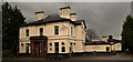
2
Grange Manor Public House, Gateacre
Grange Manor pub in Grange Lane, Gateacre. Grange Lane follows the line of an old packhorse trail, which led from the Mersey crossing at Hale to the township of West Derby in the days before Liverpool even existed. Originally called Gorsey Cop, the name originating from an Anglo-Saxon word meaning head or top, of a hill or rise covered in gorse. A farm of that name appeared on 1768 map and was there until the 1960's when the land was used for housing. The house itself was built between 1871-1881 for a wealthy gentleman, a rural retreat on high ground with superb views across the farmland and heathland to Huyton and Prescot. A Manchester cotton broker lived there in 1881, possibly the original occupant. The name Gorsey Cop was kept when it became a nightclub/casino around the 1960's but was changed to Grange Manor in more recent years.
Image: © Sue Adair
Taken: 14 Jan 2007
0.08 miles
3
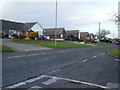
Childwall Lane joins Rockbourne Avenue
Image: © Raymond Knapman
Taken: 24 Apr 2012
0.10 miles
4
Grange Lane, Gateacre.
View north with Superlambanana sculpture being transported away after display at Gateacre Comprehensive School Art exhibition.
Image: © Colin Pyle
Taken: 26 Sep 2008
0.11 miles
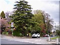
5
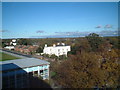
Grange Lane, Gateacre
View looking north from Gateacre Comprehensive School.
Image: © Colin Pyle
Taken: 1 Jan 2003
0.11 miles
8
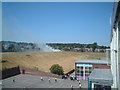
Gateacre Comprehensive School
Grassfire on school playing field.
Image: © Colin Pyle
Taken: 16 Jul 2006
0.14 miles
9
Gateacre Comprehensive School
Playing fields with Gateacre Park Drive beyond.
Image: © Colin Pyle
Taken: 2 Feb 2009
0.14 miles
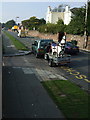
10
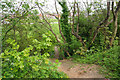
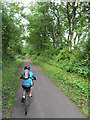
Informal path off the Trans Pennine Trail
There are plenty of official paths off the trail, but this is an extra one down the side of the embankment.
Image: © Bill Boaden
Taken: 24 Apr 2019
0.15 miles