IMAGES TAKEN NEAR TO
Gateacre Park Drive, LIVERPOOL, L25 1PB
Introduction
This page details the photographs taken nearby to Gateacre Park Drive, L25 1PB by members of the Geograph project.
The Geograph project started in 2005 with the aim of publishing, organising and preserving representative images for every square kilometre of Great Britain, Ireland and the Isle of Man.

There are currently over 7.5m images from over14,400 individuals and you can help contribute to the project by visiting https://www.geograph.org.uk
Image Map
Images are licensed for reuse under creativecommons.org/licenses/by-sa/2.0
Notes
- Clicking on the map will re-center to the selected point.
- The higher the marker number, the further away the image location is from the centre of the postcode.
Image Listing (15 Images Found)
Images are licensed for reuse under creativecommons.org/licenses/by-sa/2.0
Image
Details
Distance
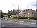
1
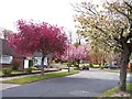
Spring in suburbia
Ornamental trees in blossom on Wallgate Road
Image: © Raymond Knapman
Taken: 24 Apr 2012
0.07 miles
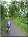
2
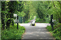
Trans Pennine Trail
The route of the former Liverpool Loop Line here crossing Escor Road.
Image: © Bill Boaden
Taken: 24 Apr 2019
0.10 miles
3
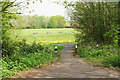
Path off the Trans Pennine Trail
The path goes onto one of the green spaces in the area, this one called Lyndene.
Image: © Bill Boaden
Taken: 24 Apr 2019
0.10 miles
4
Alderman John Village Gardens
On old maps, Childwall Brook springs up near Well Lane on Childwall Lane and is marked as Monk’s Well. This flowed towards the Cistern Pit (known locally as Jackson’s Pond) which lay between the Loop Line and Gateacre Park Drive and this is now the site of Alderman John Village Gardens. The Loop Line was abandoned in 1964 by British Rail and this disused railway line is now part of the Trans Pennine Trail from Halewood to Aintree and can be accessed from the park.
Image: © Sue Adair
Taken: 7 May 2020
0.12 miles
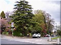
5
Colton Road joins Lyndene Road at Childwall
Trans Pennine Trail bridges Lyndene Road in background
Image: © Raymond Knapman
Taken: 24 Apr 2012
0.14 miles
6
Childwall Lane joins Rockbourne Avenue
Image: © Raymond Knapman
Taken: 24 Apr 2012
0.14 miles
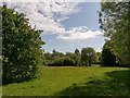
7
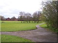
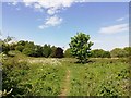
Parkland at Lyndene
The path in the foreground leads to the Trans Pennine Trail.
Image: © Raymond Knapman
Taken: 24 Apr 2012
0.15 miles
9
Footpath through Childwall Fields
Childwall Fields was once the parkland of the 18th Century Childwall Hall. In 1947, the 5th Marquess of Salisbury presented Childwall Hall to Liverpool Corporation who intended to establish a county college, however the house was found to be unsuitable and riddled with dry rot, it was demolished in 1949. For more information:- http://www.childwall.info/childwall-hall/4576517933
As part of the Mersey Forest project and planted with native deciduous trees, this area and adjoining woodlands is capable of supporting a wide range of species.
Image: © Sue Adair
Taken: 7 May 2020
0.19 miles
10
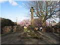
Childwall Cross
Thought to be a market cross approximately 600 years old, Childwall cross was re-erected just a few yards from where it was found in 1935, partly buried in a field. In total 22 sandstone blocks were found, three steps and the base but no sign of the original shaft. Lord Salisbury provided the new site and a donation to enable the cross to be rebuilt in its present position on Childwall Lane.
Image: © Sue Adair
Taken: 27 Mar 2009
0.20 miles