IMAGES TAKEN NEAR TO
St. Matthews Avenue, LIVERPOOL, L21 5JR
Introduction
This page details the photographs taken nearby to St. Matthews Avenue, L21 5JR by members of the Geograph project.
The Geograph project started in 2005 with the aim of publishing, organising and preserving representative images for every square kilometre of Great Britain, Ireland and the Isle of Man.

There are currently over 7.5m images from over14,400 individuals and you can help contribute to the project by visiting https://www.geograph.org.uk
Image Map
Images are licensed for reuse under creativecommons.org/licenses/by-sa/2.0
Notes
- Clicking on the map will re-center to the selected point.
- The higher the marker number, the further away the image location is from the centre of the postcode.
Image Listing (15 Images Found)
Images are licensed for reuse under creativecommons.org/licenses/by-sa/2.0
Image
Details
Distance
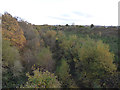
1
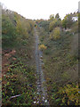
Railway to the west of Harris Drive
This cutting once contained the two tracks of the Fazakerley to Bootle (North Mersey) line. Only one track remains, and this apparently has been disused since 2005 (the line saw no regular traffic since it lost its connection to the docks in 1971). Although the route would make a fine cycleway, as an extension of the Liverpool Extension Line (NCN62), it seems Network Rail wants to hang on to it just in case a passenger service can be revived in future.
Image: © Stephen Craven
Taken: 4 Nov 2017
0.13 miles
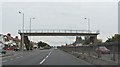
2
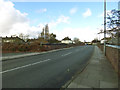
Harris Drive bridge
The bridge crosses a former railway cutting Image
Image: © Stephen Craven
Taken: 4 Nov 2017
0.15 miles
3
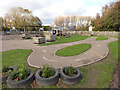
Bikeability course in a school playground
It's good to see that pupils at this school can practice their road cycling skills in total safety. This is St Robert Bellarmine Catholic Primary School in Litherland.
Image: © Stephen Craven
Taken: 4 Nov 2017
0.16 miles
4
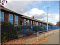
St Robert Bellarmine Primary School
A Catholic school in Litherland.
Image: © Stephen Craven
Taken: 4 Nov 2017
0.17 miles
5
Site of West End sidings
This wide cutting once contained several sidings off the Fazakerley to Bootle (North Mersey) line. There is no hint now of the sidings apart from one rusting track (not visible in this photo).
Image: © Stephen Craven
Taken: 4 Nov 2017
0.19 miles
6
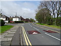
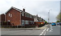
Speed humps on Orrell Road
Near the junction with Melville Road.
Image: © JThomas
Taken: 28 Apr 2019
0.19 miles
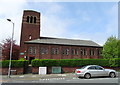
10
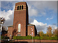
St Robert Bellarmine Church, Litherland
The church was built to the designs of L.A.G. Prichard in 1932, to serve an interwar housing estate. It is named after a 16th century Jesuit theologian. See also Image
Image: © Stephen Craven
Taken: 4 Nov 2017
0.20 miles