IMAGES TAKEN NEAR TO
Banks Road, LIVERPOOL, L19 2QG
Introduction
This page details the photographs taken nearby to Banks Road, L19 2QG by members of the Geograph project.
The Geograph project started in 2005 with the aim of publishing, organising and preserving representative images for every square kilometre of Great Britain, Ireland and the Isle of Man.

There are currently over 7.5m images from over14,400 individuals and you can help contribute to the project by visiting https://www.geograph.org.uk
Image Map
Images are licensed for reuse under creativecommons.org/licenses/by-sa/2.0
Notes
- Clicking on the map will re-center to the selected point.
- The higher the marker number, the further away the image location is from the centre of the postcode.
Image Listing (38 Images Found)
Images are licensed for reuse under creativecommons.org/licenses/by-sa/2.0
Image
Details
Distance
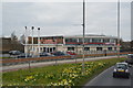
1
Bank's Road, Garston
View along Bank's Road, Garston, towards Speke Road (A561).
Image: © Mike Harris
Taken: 7 Jul 2007
0.01 miles
2
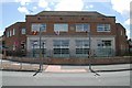
Garston old fire station
Garston old fire station, Banks Road, Garston, Liverpool, now converted into flats
Image: © Kevin Hale
Taken: 27 May 2010
0.04 miles
3
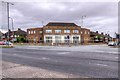
Garston Old Fire Station
The former fire station at the corner of Bank's Road and Speke Road, now converted into apartments. http://www.liverpoolviews.co.uk/south/garston/other/firestat.html shows a photo of the building whilst in use as a fire station.
Image: © David Dixon
Taken: 12 Jul 2014
0.04 miles
4
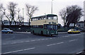
Banks Road
A Merseyside Transport bus at the junction with Speke Road. The vehicle, fleet number 1837, is an East Lancs-bodied Leyland Atlantean. Behind on the right is the Bryant & May match factory, built in 1919-21. It closed in 1994 and is now a business park. The tenement blocks on the left have been replaced by modern low-rise housing.
Image: © Martin Addison
Taken: Unknown
0.04 miles
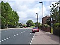
6
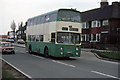
Speke Road
Merseyside Transport 1584, a Leyland Atlantean with Alexander body, approaches the junction with Banks Road. Despite regeneration of the area, the houses on the right survive though the petrol station on the left of the photo has disappeared.
Image: © Martin Addison
Taken: Unknown
0.06 miles
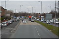
8
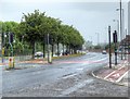
Speke Road (A561), Garston
A rainy Saturday on Speke Road.
Image: © David Dixon
Taken: 12 Jul 2014
0.07 miles
9
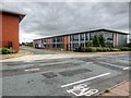
Speke, Dakota Business Park
New business park on the site of the former Speke Airport.
Image: © David Dixon
Taken: 12 Jul 2014
0.08 miles