IMAGES TAKEN NEAR TO
Dudlow Lane, LIVERPOOL, L18 2EZ
Introduction
This page details the photographs taken nearby to Dudlow Lane, L18 2EZ by members of the Geograph project.
The Geograph project started in 2005 with the aim of publishing, organising and preserving representative images for every square kilometre of Great Britain, Ireland and the Isle of Man.

There are currently over 7.5m images from over14,400 individuals and you can help contribute to the project by visiting https://www.geograph.org.uk
Image Map
Images are licensed for reuse under creativecommons.org/licenses/by-sa/2.0
Notes
- Clicking on the map will re-center to the selected point.
- The higher the marker number, the further away the image location is from the centre of the postcode.
Image Listing (10 Images Found)
Images are licensed for reuse under creativecommons.org/licenses/by-sa/2.0
Image
Details
Distance
1
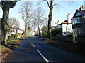
Green Lane near Childwall
Part of an area of leafy suburbs.
Image: © Bill Boaden
Taken: 21 Feb 2015
0.14 miles
2
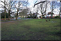
Green space by Green Lane
The white bits are snowdrops heralding spring on the way.
Image: © Bill Boaden
Taken: 21 Feb 2015
0.15 miles
5
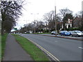
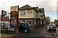
Parade of shops on Woolton Road
While visiting our son and his family we had an excellent lunch at Cucina Di Vincenzo, to please four adults and three teenage girls it had to be good and it was. Fourth from the right in this parade
Image: © Martin Dawes
Taken: 10 Nov 2018
0.17 miles
6
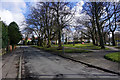
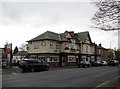
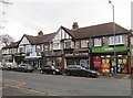
Assorted suburban shops
Woolton Road, at junction with Hattons Lane.
Image: © Peter Barr
Taken: 3 Nov 2012
0.17 miles
7
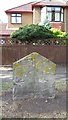
Old Boundary Marker
Parish Boundary Marker on the north side of Green Lane, on the verge outside number 29. Liverpool metropolitan district. No inscription, just an inscribed vertical line. Showing the boundary of Wavertree and Allerton townships' responsibility for road maintenance. Reference http://www.liverpool.ndo.co.uk/wavsoc/news20/index.html.
Milestone Society National ID: LA_LVWVAL01pb
Image: © M Chitty, Wavertree Society
Taken: 10 Aug 2018
0.23 miles
8
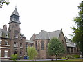
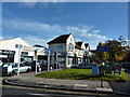
Bishop Eton Monastery, Woolton
Bishop Eton Monastery on Woolton Road near to the junction with Crompton's Lane.
Image: © Sue Adair
Taken: 16 Aug 2005
0.24 miles