IMAGES TAKEN NEAR TO
Friars Way, LIVERPOOL, L14 7BA
Introduction
This page details the photographs taken nearby to Friars Way, L14 7BA by members of the Geograph project.
The Geograph project started in 2005 with the aim of publishing, organising and preserving representative images for every square kilometre of Great Britain, Ireland and the Isle of Man.

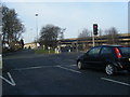
There are currently over 7.5m images from over14,400 individuals and you can help contribute to the project by visiting https://www.geograph.org.uk
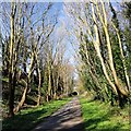
Image Map
Images are licensed for reuse under creativecommons.org/licenses/by-sa/2.0
Notes
- Clicking on the map will re-center to the selected point.
- The higher the marker number, the further away the image location is from the centre of the postcode.
Image Listing (33 Images Found)
Images are licensed for reuse under creativecommons.org/licenses/by-sa/2.0
Image
Details
Distance
1
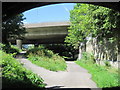
Three bridges on the Transpennine Trail
Three bridges on the Transpennine Trail at Broadgreen, Bowring Park Road, the M62 and the Liverpool to Manchester Railway. The trail crosses from coast-to-coast between Southport and Hornsea is 215 miles long, much of it on disused railway tracks.
Image: © Sue Adair
Taken: 28 Jun 2011
0.08 miles
2
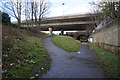
Cycle Path 62
Here it is going under the M62 motorway and then the original Liverpool to Manchester railway.
Image: © Bill Boaden
Taken: 21 Feb 2015
0.09 miles
3
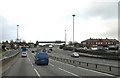
End of the M 62
End of the M 62 at Broadgreen
Image: © Galatas
Taken: 8 Feb 2008
0.10 miles
4
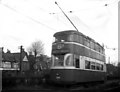
Nearly the end at Liverpool
By 1957, the once-great Liverpool tramway system had been reduced to just two routes, the 6A to Bowring Park and the 40 to Page Moss Avenue. These routes finally closed in September. All was in a run-down and dilapidated condition, sad to see. Here is a 'Baby Grand' 4-wheel tram on the Bowring Park route.
Image: © Dr Neil Clifton
Taken: 11 Apr 1957
0.12 miles
5
Bowring Park Road/Rocky Lane junction.
To the right is the end of the M62 motorway, which drops down to become Bowring Park road.
Image: © Colin Pyle
Taken: 21 Jan 2010
0.12 miles
6
Liverpool Loop Line at Broad Green
This popular walking and cycling route follows the old railway line which was abandoned in 1964 and forms part of the Trans Pennine Trail.
Image: © Sue Adair
Taken: 24 Mar 2019
0.12 miles
7
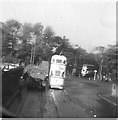
Last Tram at Broadgreen
The last tram, number 6A, ran from the Pier Head to Bowring Park on September 14th 1957. The photograph was taken from the old bridge at Broadgreen looking towards Lucas' Victor Works.
Image: © Sue Adair
Taken: 14 Sep 1957
0.13 miles
8
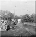
Trams approaching Broadgreen Bridge
The last two trams to run on Liverpool's tramway system, the 6A being one of the only two remaining routes. On 14th September 1957 a procession of trams, with Liverpool's official last tram (Baby Grand 293) in the rear, left the Pier Head via the city centre to travel to the terminus at Bowring Park.
Image: © Sue Adair
Taken: 14 Sep 1957
0.13 miles
9
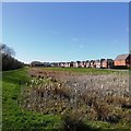
Bulrush Pond, Thingwall
Bulrush pond on the new Thingwall Summerhill Park estate, a narrow public footpath runs alongside the railway embankment.
Image: © Sue Adair
Taken: 24 Mar 2019
0.13 miles
10
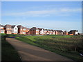
Summerhill Park and Boggy Pond
A new footpath through the Summerhill Park development links Penrose Avenue West with the Liverpool Loop Line cycle trail at Broadgreen.
Image: © Sue Adair
Taken: 17 Dec 2018
0.14 miles